You are here: Home > Network List > TA - USArray Transportable Network (new EarthScope stations) Stations List
> Station L19A Farson, WY, USA > Earthquake Result Viewer
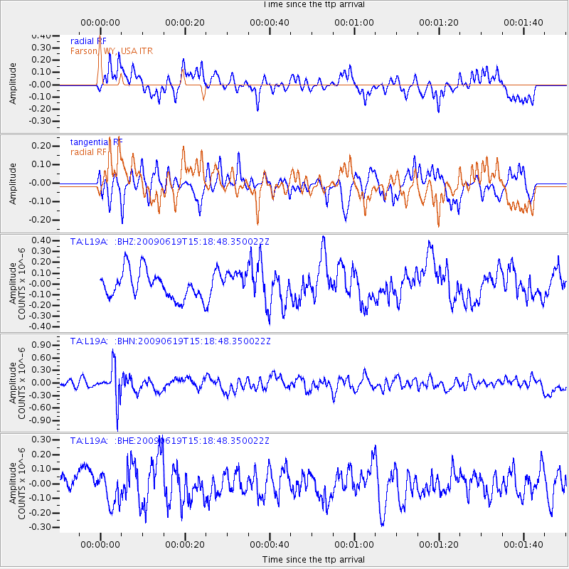
L19A Farson, WY, USA - Earthquake Result Viewer
*The percent match for this event was below the threshold and hence no stack was calculated.
| Earthquake location: |
Mariana Islands |
| Earthquake latitude/longitude: |
14.1/145.2 |
| Earthquake time(UTC): |
2009/06/19 (170) 15:06:24 GMT |
| Earthquake Depth: |
114 km |
| Earthquake Magnitude: |
5.5 MB, 5.5 MW |
| Earthquake Catalog/Contributor: |
WHDF/NEIC |
|
| Network: |
TA USArray Transportable Network (new EarthScope stations) |
| Station: |
L19A Farson, WY, USA |
| Lat/Lon: |
42.10 N/109.36 W |
| Elevation: |
2034 m |
|
| Distance: |
91.8 deg |
| Az: |
45.86 deg |
| Baz: |
290.654 deg |
| Ray Param: |
$rayparam |
*The percent match for this event was below the threshold and hence was not used in the summary stack. |
|
| Radial Match: |
62.796017 % |
| Radial Bump: |
400 |
| Transverse Match: |
51.59885 % |
| Transverse Bump: |
351 |
| SOD ConfigId: |
2648 |
| Insert Time: |
2010-03-06 00:50:31.487 +0000 |
| GWidth: |
2.5 |
| Max Bumps: |
400 |
| Tol: |
0.001 |
|
Signal To Noise
| Channel | StoN | STA | LTA |
| TA:L19A: :BHN:20090619T15:18:48.350022Z | 3.6163428 | 3.9141227E-7 | 1.0823428E-7 |
| TA:L19A: :BHE:20090619T15:18:48.350022Z | 0.99442786 | 1.0990778E-7 | 1.1052364E-7 |
| TA:L19A: :BHZ:20090619T15:18:48.350022Z | 0.8404741 | 1.0521886E-7 | 1.2518989E-7 |
| Arrivals |
| Ps | |
| PpPs | |
| PsPs/PpSs | |


