You are here: Home > Network List > TA - USArray Transportable Network (new EarthScope stations) Stations List
> Station F22K John River, AK, USA > Earthquake Result Viewer
F22K John River, AK, USA - Earthquake Result Viewer
| Earthquake location: |
Near Coast Of Chiapas, Mexico |
| Earthquake latitude/longitude: |
14.2/-93.2 |
| Earthquake time(UTC): |
2017/06/14 (165) 06:38:48 GMT |
| Earthquake Depth: |
11 km |
| Earthquake Magnitude: |
5.5 Mww |
| Earthquake Catalog/Contributor: |
NEIC PDE/us |
|
| Network: |
TA USArray Transportable Network (new EarthScope stations) |
| Station: |
F22K John River, AK, USA |
| Lat/Lon: |
67.51 N/152.18 W |
| Elevation: |
546 m |
|
| Distance: |
65.3 deg |
| Az: |
338.713 deg |
| Baz: |
113.797 deg |
| Ray Param: |
0.058341153 |
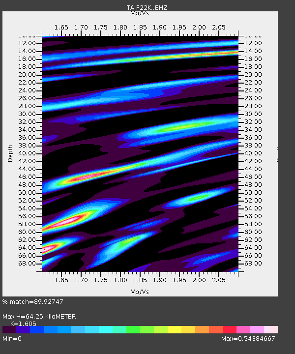
| Estimated Moho Depth: |
64.25 km |
| Estimated Crust Vp/Vs: |
1.61 |
| Assumed Crust Vp: |
6.455 km/s |
| Estimated Crust Vs: |
4.022 km/s |
| Estimated Crust Poisson's Ratio: |
0.18 |
|
| Radial Match: |
89.92747 % |
| Radial Bump: |
400 |
| Transverse Match: |
76.62618 % |
| Transverse Bump: |
400 |
| SOD ConfigId: |
13570011 |
| Insert Time: |
2019-04-28 04:58:04.525 +0000 |
| GWidth: |
2.5 |
| Max Bumps: |
400 |
| Tol: |
0.001 |
|

Signal To Noise
| Channel | StoN | STA | LTA |
| TA:F22K: :BHZ:20170614T06:48:59.750002Z | 8.811305 | 3.6451365E-7 | 4.136886E-8 |
| TA:F22K: :BHN:20170614T06:48:59.750002Z | 2.0293205 | 7.829844E-8 | 3.8583575E-8 |
| TA:F22K: :BHE:20170614T06:48:59.750002Z | 8.2816725 | 1.9142881E-7 | 2.3114753E-8 |
| Arrivals |
| Ps | 6.3 SECOND |
| PpPs | 25 SECOND |
| PsPs/PpSs | 31 SECOND |


