You are here: Home > Network List > TA - USArray Transportable Network (new EarthScope stations) Stations List
> Station L19A Farson, WY, USA > Earthquake Result Viewer
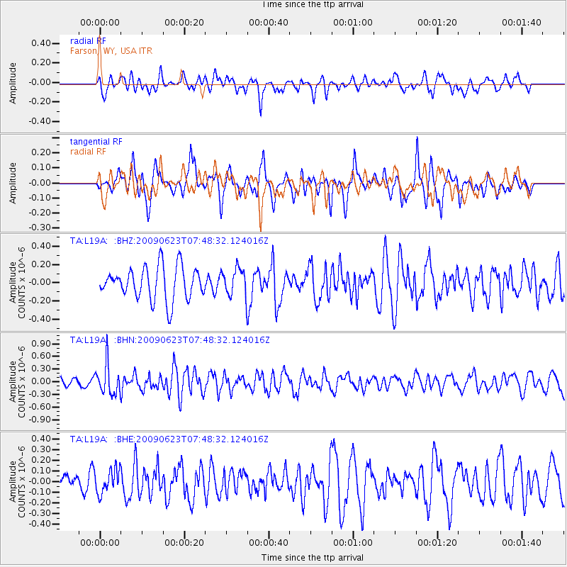
L19A Farson, WY, USA - Earthquake Result Viewer
*The percent match for this event was below the threshold and hence no stack was calculated.
| Earthquake location: |
Near East Coast Of Honshu, Japan |
| Earthquake latitude/longitude: |
38.8/142.4 |
| Earthquake time(UTC): |
2009/06/23 (174) 07:37:17 GMT |
| Earthquake Depth: |
37 km |
| Earthquake Magnitude: |
5.7 MB, 5.0 MS, 5.6 MW, 5.6 MW |
| Earthquake Catalog/Contributor: |
WHDF/NEIC |
|
| Network: |
TA USArray Transportable Network (new EarthScope stations) |
| Station: |
L19A Farson, WY, USA |
| Lat/Lon: |
42.10 N/109.36 W |
| Elevation: |
2034 m |
|
| Distance: |
76.4 deg |
| Az: |
46.649 deg |
| Baz: |
310.273 deg |
| Ray Param: |
$rayparam |
*The percent match for this event was below the threshold and hence was not used in the summary stack. |
|
| Radial Match: |
43.848457 % |
| Radial Bump: |
400 |
| Transverse Match: |
58.69487 % |
| Transverse Bump: |
394 |
| SOD ConfigId: |
2648 |
| Insert Time: |
2010-03-06 00:50:41.420 +0000 |
| GWidth: |
2.5 |
| Max Bumps: |
400 |
| Tol: |
0.001 |
|
Signal To Noise
| Channel | StoN | STA | LTA |
| TA:L19A: :BHN:20090623T07:48:32.124016Z | 3.6093864 | 3.6604112E-7 | 1.0141367E-7 |
| TA:L19A: :BHE:20090623T07:48:32.124016Z | 1.0420976 | 1.1408952E-7 | 1.09480645E-7 |
| TA:L19A: :BHZ:20090623T07:48:32.124016Z | 0.86640066 | 1.5534276E-7 | 1.7929668E-7 |
| Arrivals |
| Ps | |
| PpPs | |
| PsPs/PpSs | |


