You are here: Home > Network List > TA - USArray Transportable Network (new EarthScope stations) Stations List
> Station L19A Farson, WY, USA > Earthquake Result Viewer
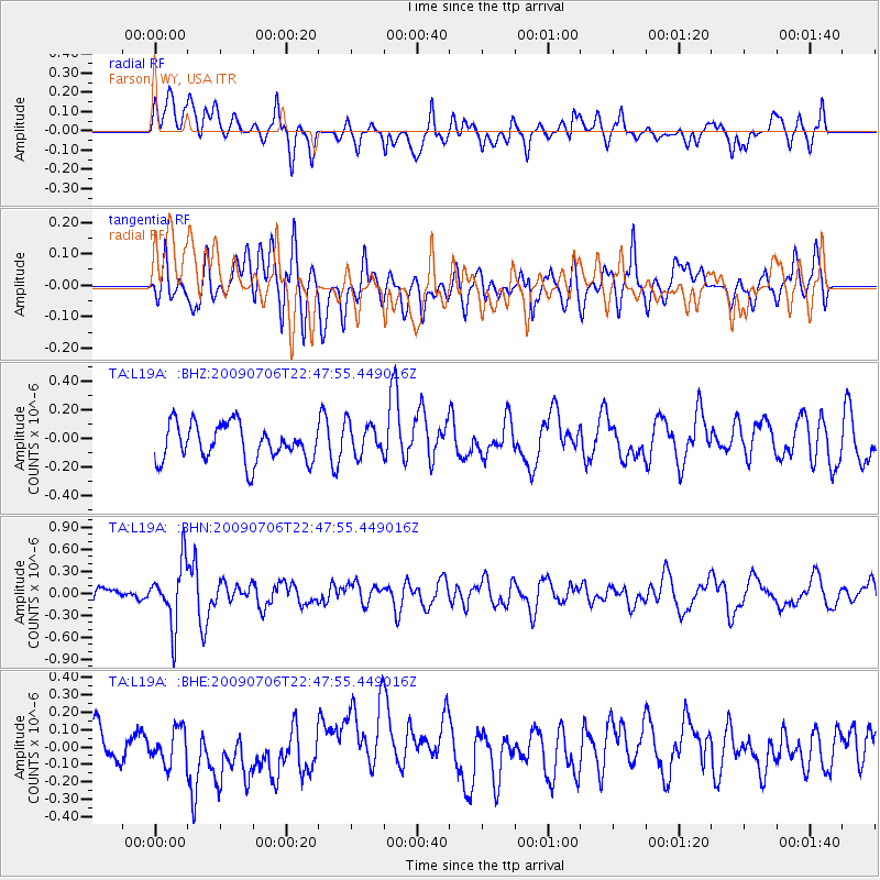
L19A Farson, WY, USA - Earthquake Result Viewer
*The percent match for this event was below the threshold and hence no stack was calculated.
| Earthquake location: |
Southeast Of Ryukyu Islands |
| Earthquake latitude/longitude: |
24.9/128.0 |
| Earthquake time(UTC): |
2009/07/06 (187) 22:35:05 GMT |
| Earthquake Depth: |
10 km |
| Earthquake Magnitude: |
6.1 MB, 5.3 MS, 5.7 MW, 5.7 MW |
| Earthquake Catalog/Contributor: |
WHDF/NEIC |
|
| Network: |
TA USArray Transportable Network (new EarthScope stations) |
| Station: |
L19A Farson, WY, USA |
| Lat/Lon: |
42.10 N/109.36 W |
| Elevation: |
2034 m |
|
| Distance: |
94.9 deg |
| Az: |
38.985 deg |
| Baz: |
309.839 deg |
| Ray Param: |
$rayparam |
*The percent match for this event was below the threshold and hence was not used in the summary stack. |
|
| Radial Match: |
44.22884 % |
| Radial Bump: |
400 |
| Transverse Match: |
50.79154 % |
| Transverse Bump: |
400 |
| SOD ConfigId: |
2648 |
| Insert Time: |
2010-03-06 00:50:45.181 +0000 |
| GWidth: |
2.5 |
| Max Bumps: |
400 |
| Tol: |
0.001 |
|
Signal To Noise
| Channel | StoN | STA | LTA |
| TA:L19A: :BHN:20090706T22:47:55.449016Z | 2.7392118 | 4.1736632E-7 | 1.523673E-7 |
| TA:L19A: :BHE:20090706T22:47:55.449016Z | 0.86472327 | 1.13569854E-7 | 1.3133665E-7 |
| TA:L19A: :BHZ:20090706T22:47:55.449016Z | 0.9087526 | 1.1559606E-7 | 1.2720301E-7 |
| Arrivals |
| Ps | |
| PpPs | |
| PsPs/PpSs | |


