You are here: Home > Network List > TA - USArray Transportable Network (new EarthScope stations) Stations List
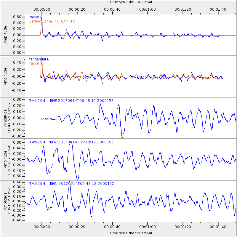
> Station K29M Barlow Dome, YT, CAN > Earthquake Result Viewer
K29M Barlow Dome, YT, CAN - Earthquake Result Viewer
| Earthquake location: |
Near Coast Of Chiapas, Mexico |
| Earthquake latitude/longitude: |
14.2/-93.2 |
| Earthquake time(UTC): |
2017/06/14 (165) 06:38:48 GMT |
| Earthquake Depth: |
11 km |
| Earthquake Magnitude: |
5.5 Mww |
| Earthquake Catalog/Contributor: |
NEIC PDE/us |
|
| Network: |
TA USArray Transportable Network (new EarthScope stations) |
| Station: |
K29M Barlow Dome, YT, CAN |
| Lat/Lon: |
63.84 N/137.52 W |
| Elevation: |
1367 m |
|
| Distance: |
58.3 deg |
| Az: |
338.626 deg |
| Baz: |
127.117 deg |
| Ray Param: |
0.06296146 |
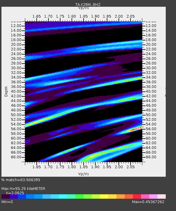
| Estimated Moho Depth: |
55.25 km |
| Estimated Crust Vp/Vs: |
2.09 |
| Assumed Crust Vp: |
6.566 km/s |
| Estimated Crust Vs: |
3.138 km/s |
| Estimated Crust Poisson's Ratio: |
0.35 |
|
| Radial Match: |
83.586395 % |
| Radial Bump: |
380 |
| Transverse Match: |
66.7594 % |
| Transverse Bump: |
400 |
| SOD ConfigId: |
13570011 |
| Insert Time: |
2019-04-28 04:58:37.950 +0000 |
| GWidth: |
2.5 |
| Max Bumps: |
400 |
| Tol: |
0.001 |
|
Signal To Noise
| Channel | StoN | STA | LTA |
| TA:K29M: :BHZ:20170614T06:48:12.200015Z | 6.0429645 | 3.3054036E-7 | 5.469838E-8 |
| TA:K29M: :BHN:20170614T06:48:12.200015Z | 1.394275 | 1.09003274E-7 | 7.8179184E-8 |
| TA:K29M: :BHE:20170614T06:48:12.200015Z | 3.2604177 | 1.3080769E-7 | 4.0119918E-8 |
| Arrivals |
| Ps | 9.6 SECOND |
| PpPs | 25 SECOND |
| PsPs/PpSs | 35 SECOND |


