You are here: Home > Network List > TA - USArray Transportable Network (new EarthScope stations) Stations List
> Station L19A Farson, WY, USA > Earthquake Result Viewer
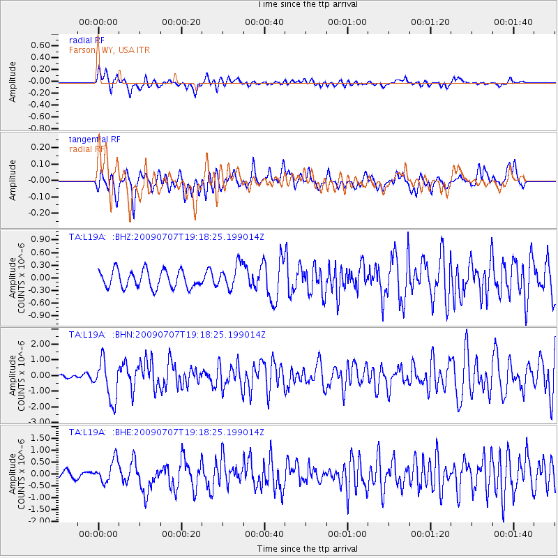
L19A Farson, WY, USA - Earthquake Result Viewer
*The percent match for this event was below the threshold and hence no stack was calculated.
| Earthquake location: |
Baffin Bay |
| Earthquake latitude/longitude: |
75.4/-72.5 |
| Earthquake time(UTC): |
2009/07/07 (188) 19:11:46 GMT |
| Earthquake Depth: |
19 km |
| Earthquake Magnitude: |
5.9 MB, 5.7 MS, 6.1 MW, 6.0 MW |
| Earthquake Catalog/Contributor: |
WHDF/NEIC |
|
| Network: |
TA USArray Transportable Network (new EarthScope stations) |
| Station: |
L19A Farson, WY, USA |
| Lat/Lon: |
42.10 N/109.36 W |
| Elevation: |
2034 m |
|
| Distance: |
37.1 deg |
| Az: |
227.779 deg |
| Baz: |
14.67 deg |
| Ray Param: |
$rayparam |
*The percent match for this event was below the threshold and hence was not used in the summary stack. |
|
| Radial Match: |
64.65469 % |
| Radial Bump: |
400 |
| Transverse Match: |
56.065804 % |
| Transverse Bump: |
400 |
| SOD ConfigId: |
2648 |
| Insert Time: |
2010-03-06 00:50:48.702 +0000 |
| GWidth: |
2.5 |
| Max Bumps: |
400 |
| Tol: |
0.001 |
|
Signal To Noise
| Channel | StoN | STA | LTA |
| TA:L19A: :BHN:20090707T19:18:25.199014Z | 7.428268 | 1.3006932E-6 | 1.7510045E-7 |
| TA:L19A: :BHE:20090707T19:18:25.199014Z | 3.3553123 | 4.952685E-7 | 1.4760728E-7 |
| TA:L19A: :BHZ:20090707T19:18:25.199014Z | 1.4622751 | 2.982144E-7 | 2.0393863E-7 |
| Arrivals |
| Ps | |
| PpPs | |
| PsPs/PpSs | |


