You are here: Home > Network List > TA - USArray Transportable Network (new EarthScope stations) Stations List
> Station MDND Maddock, ND, USA > Earthquake Result Viewer
MDND Maddock, ND, USA - Earthquake Result Viewer
*The percent match for this event was below the threshold and hence no stack was calculated.
| Earthquake location: |
Near Coast Of Chiapas, Mexico |
| Earthquake latitude/longitude: |
14.2/-93.2 |
| Earthquake time(UTC): |
2017/06/14 (165) 06:38:48 GMT |
| Earthquake Depth: |
11 km |
| Earthquake Magnitude: |
5.5 Mww |
| Earthquake Catalog/Contributor: |
NEIC PDE/us |
|
| Network: |
TA USArray Transportable Network (new EarthScope stations) |
| Station: |
MDND Maddock, ND, USA |
| Lat/Lon: |
47.85 N/99.60 W |
| Elevation: |
479 m |
|
| Distance: |
34.0 deg |
| Az: |
352.21 deg |
| Baz: |
168.747 deg |
| Ray Param: |
$rayparam |
*The percent match for this event was below the threshold and hence was not used in the summary stack. |
|
| Radial Match: |
60.97741 % |
| Radial Bump: |
400 |
| Transverse Match: |
47.187843 % |
| Transverse Bump: |
400 |
| SOD ConfigId: |
13570011 |
| Insert Time: |
2019-04-28 04:59:01.585 +0000 |
| GWidth: |
2.5 |
| Max Bumps: |
400 |
| Tol: |
0.001 |
|
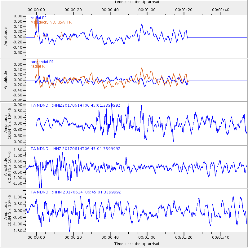
Signal To Noise
| Channel | StoN | STA | LTA |
| TA:MDND: :HHZ:20170614T06:45:01.339999Z | 5.3720827 | 7.274127E-7 | 1.3540608E-7 |
| TA:MDND: :HHN:20170614T06:45:01.339999Z | 2.30378 | 5.609987E-7 | 2.4351226E-7 |
| TA:MDND: :HHE:20170614T06:45:01.339999Z | 1.7669454 | 2.5758035E-7 | 1.4577721E-7 |
| Arrivals |
| Ps | |
| PpPs | |
| PsPs/PpSs | |


