You are here: Home > Network List > TA - USArray Transportable Network (new EarthScope stations) Stations List
> Station L19A Farson, WY, USA > Earthquake Result Viewer
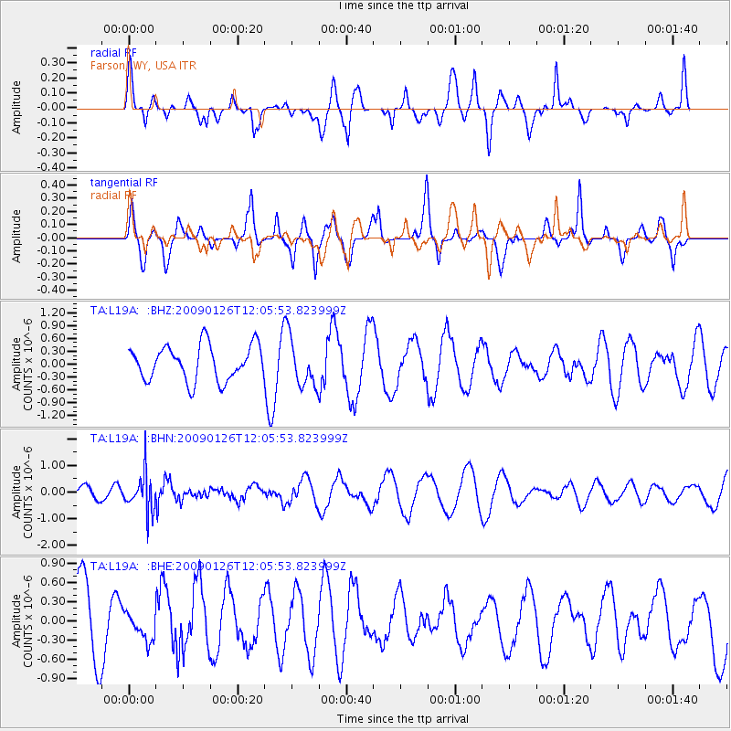
L19A Farson, WY, USA - Earthquake Result Viewer
*The percent match for this event was below the threshold and hence no stack was calculated.
| Earthquake location: |
Fiji Islands Region |
| Earthquake latitude/longitude: |
-17.8/-178.6 |
| Earthquake time(UTC): |
2009/01/26 (026) 11:54:39 GMT |
| Earthquake Depth: |
580 km |
| Earthquake Magnitude: |
5.5 MB, 5.8 MW, 5.8 MW |
| Earthquake Catalog/Contributor: |
WHDF/NEIC |
|
| Network: |
TA USArray Transportable Network (new EarthScope stations) |
| Station: |
L19A Farson, WY, USA |
| Lat/Lon: |
42.10 N/109.36 W |
| Elevation: |
2034 m |
|
| Distance: |
87.2 deg |
| Az: |
44.16 deg |
| Baz: |
243.113 deg |
| Ray Param: |
$rayparam |
*The percent match for this event was below the threshold and hence was not used in the summary stack. |
|
| Radial Match: |
32.918163 % |
| Radial Bump: |
400 |
| Transverse Match: |
46.72399 % |
| Transverse Bump: |
400 |
| SOD ConfigId: |
2658 |
| Insert Time: |
2010-03-06 00:50:59.331 +0000 |
| GWidth: |
2.5 |
| Max Bumps: |
400 |
| Tol: |
0.001 |
|
Signal To Noise
| Channel | StoN | STA | LTA |
| TA:L19A: :BHN:20090126T12:05:53.823999Z | 2.425816 | 7.0147547E-7 | 2.891709E-7 |
| TA:L19A: :BHE:20090126T12:05:53.823999Z | 0.3341497 | 2.1374447E-7 | 6.396668E-7 |
| TA:L19A: :BHZ:20090126T12:05:53.823999Z | 1.3693262 | 5.5866246E-7 | 4.0798344E-7 |
| Arrivals |
| Ps | |
| PpPs | |
| PsPs/PpSs | |


