You are here: Home > Network List > TA - USArray Transportable Network (new EarthScope stations) Stations List
> Station O16K Kokwok River, Bristol Bay, AK, USA > Earthquake Result Viewer
O16K Kokwok River, Bristol Bay, AK, USA - Earthquake Result Viewer
| Earthquake location: |
Near Coast Of Chiapas, Mexico |
| Earthquake latitude/longitude: |
14.2/-93.2 |
| Earthquake time(UTC): |
2017/06/14 (165) 06:38:48 GMT |
| Earthquake Depth: |
11 km |
| Earthquake Magnitude: |
5.5 Mww |
| Earthquake Catalog/Contributor: |
NEIC PDE/us |
|
| Network: |
TA USArray Transportable Network (new EarthScope stations) |
| Station: |
O16K Kokwok River, Bristol Bay, AK, USA |
| Lat/Lon: |
59.59 N/158.09 W |
| Elevation: |
198 m |
|
| Distance: |
65.2 deg |
| Az: |
329.502 deg |
| Baz: |
104.635 deg |
| Ray Param: |
0.05841362 |
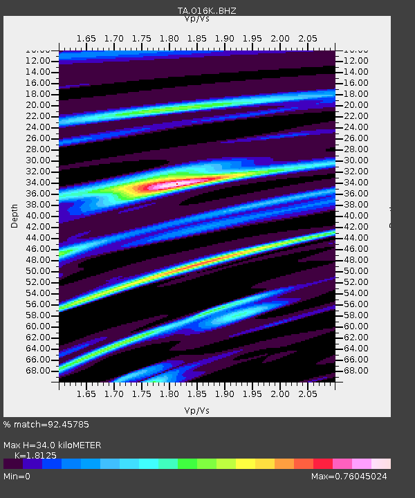
| Estimated Moho Depth: |
34.0 km |
| Estimated Crust Vp/Vs: |
1.81 |
| Assumed Crust Vp: |
6.24 km/s |
| Estimated Crust Vs: |
3.443 km/s |
| Estimated Crust Poisson's Ratio: |
0.28 |
|
| Radial Match: |
92.45785 % |
| Radial Bump: |
299 |
| Transverse Match: |
80.66454 % |
| Transverse Bump: |
400 |
| SOD ConfigId: |
13570011 |
| Insert Time: |
2019-04-28 04:59:10.877 +0000 |
| GWidth: |
2.5 |
| Max Bumps: |
400 |
| Tol: |
0.001 |
|

Signal To Noise
| Channel | StoN | STA | LTA |
| TA:O16K: :BHZ:20170614T06:48:59.025027Z | 8.984587 | 3.8499863E-7 | 4.2851013E-8 |
| TA:O16K: :BHN:20170614T06:48:59.025027Z | 1.2724745 | 5.3920726E-8 | 4.2374698E-8 |
| TA:O16K: :BHE:20170614T06:48:59.025027Z | 3.3902848 | 1.5064967E-7 | 4.4435694E-8 |
| Arrivals |
| Ps | 4.6 SECOND |
| PpPs | 15 SECOND |
| PsPs/PpSs | 19 SECOND |


