You are here: Home > Network List > TD - TransAlta Monitoring Network Stations List
> Station TD010 Z > Earthquake Result Viewer
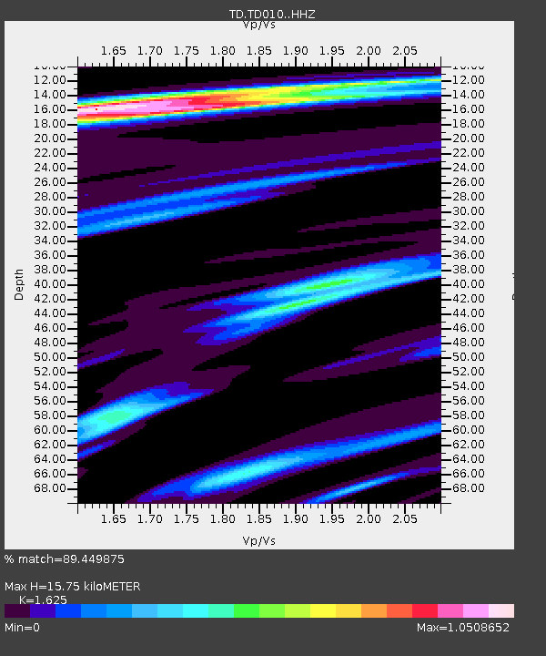
TD010 Z - Earthquake Result Viewer
| Earthquake location: |
Near Coast Of Chiapas, Mexico |
| Earthquake latitude/longitude: |
14.2/-93.2 |
| Earthquake time(UTC): |
2017/06/14 (165) 06:38:48 GMT |
| Earthquake Depth: |
11 km |
| Earthquake Magnitude: |
5.5 Mww |
| Earthquake Catalog/Contributor: |
NEIC PDE/us |
|
| Network: |
TD TransAlta Monitoring Network |
| Station: |
TD010 Z |
| Lat/Lon: |
52.64 N/116.33 W |
| Elevation: |
1637 m |
|
| Distance: |
42.5 deg |
| Az: |
339.215 deg |
| Baz: |
145.621 deg |
| Ray Param: |
0.0731164 |
| Estimated Moho Depth: |
15.75 km |
| Estimated Crust Vp/Vs: |
1.62 |
| Assumed Crust Vp: |
6.142 km/s |
| Estimated Crust Vs: |
3.78 km/s |
| Estimated Crust Poisson's Ratio: |
0.20 |
|
| Radial Match: |
89.449875 % |
| Radial Bump: |
378 |
| Transverse Match: |
73.43206 % |
| Transverse Bump: |
400 |
| SOD ConfigId: |
13570011 |
| Insert Time: |
2019-04-28 04:59:36.948 +0000 |
| GWidth: |
2.5 |
| Max Bumps: |
400 |
| Tol: |
0.001 |
|

Signal To Noise
| Channel | StoN | STA | LTA |
| TD:TD010: :HHZ:20170614T06:46:13.480013Z | 6.7784405 | 8.0639774E-7 | 1.1896508E-7 |
| TD:TD010: :HH1:20170614T06:46:13.480013Z | 4.3940682 | 3.647415E-7 | 8.3007706E-8 |
| TD:TD010: :HH2:20170614T06:46:13.480013Z | 3.1005566 | 2.055876E-7 | 6.6306676E-8 |
| Arrivals |
| Ps | 1.7 SECOND |
| PpPs | 6.3 SECOND |
| PsPs/PpSs | 8.0 SECOND |


