You are here: Home > Network List > TA - USArray Transportable Network (new EarthScope stations) Stations List
> Station L19A Farson, WY, USA > Earthquake Result Viewer
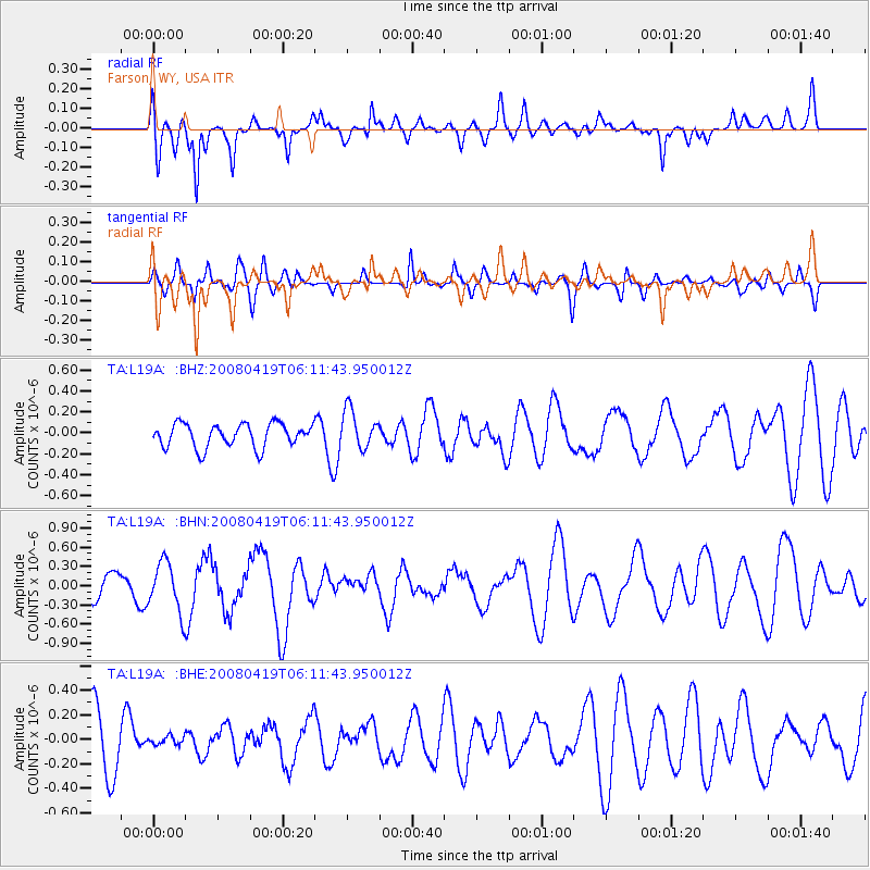
L19A Farson, WY, USA - Earthquake Result Viewer
*The percent match for this event was below the threshold and hence no stack was calculated.
| Earthquake location: |
Loyalty Islands |
| Earthquake latitude/longitude: |
-20.3/168.8 |
| Earthquake time(UTC): |
2008/04/19 (110) 05:58:42 GMT |
| Earthquake Depth: |
14 km |
| Earthquake Magnitude: |
5.7 MB, 6.2 MS, 6.3 MW, 6.2 MW |
| Earthquake Catalog/Contributor: |
WHDF/NEIC |
|
| Network: |
TA USArray Transportable Network (new EarthScope stations) |
| Station: |
L19A Farson, WY, USA |
| Lat/Lon: |
42.10 N/109.36 W |
| Elevation: |
2034 m |
|
| Distance: |
97.5 deg |
| Az: |
47.994 deg |
| Baz: |
249.618 deg |
| Ray Param: |
$rayparam |
*The percent match for this event was below the threshold and hence was not used in the summary stack. |
|
| Radial Match: |
60.048466 % |
| Radial Bump: |
400 |
| Transverse Match: |
38.40697 % |
| Transverse Bump: |
299 |
| SOD ConfigId: |
2504 |
| Insert Time: |
2010-03-06 00:51:14.679 +0000 |
| GWidth: |
2.5 |
| Max Bumps: |
400 |
| Tol: |
0.001 |
|
Signal To Noise
| Channel | StoN | STA | LTA |
| TA:L19A: :BHN:20080419T06:11:43.950012Z | 1.7968385 | 3.8327357E-7 | 2.133044E-7 |
| TA:L19A: :BHE:20080419T06:11:43.950012Z | 0.15730582 | 3.253085E-8 | 2.0680002E-7 |
| TA:L19A: :BHZ:20080419T06:11:43.950012Z | 1.6148896 | 1.8327408E-7 | 1.1349017E-7 |
| Arrivals |
| Ps | |
| PpPs | |
| PsPs/PpSs | |


