You are here: Home > Network List > TA - USArray Transportable Network (new EarthScope stations) Stations List
> Station L19A Farson, WY, USA > Earthquake Result Viewer
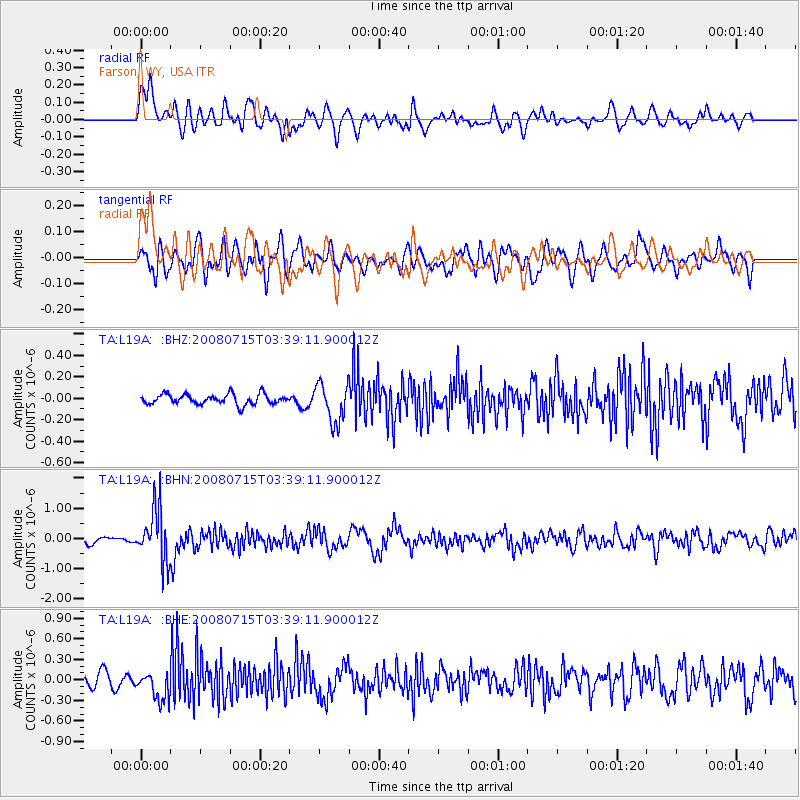
L19A Farson, WY, USA - Earthquake Result Viewer
*The percent match for this event was below the threshold and hence no stack was calculated.
| Earthquake location: |
Dodecanese Islands, Greece |
| Earthquake latitude/longitude: |
35.8/27.9 |
| Earthquake time(UTC): |
2008/07/15 (197) 03:26:34 GMT |
| Earthquake Depth: |
52 km |
| Earthquake Magnitude: |
6.5 MB, 6.4 MW, 6.4 MW |
| Earthquake Catalog/Contributor: |
WHDF/NEIC |
|
| Network: |
TA USArray Transportable Network (new EarthScope stations) |
| Station: |
L19A Farson, WY, USA |
| Lat/Lon: |
42.10 N/109.36 W |
| Elevation: |
2034 m |
|
| Distance: |
93.2 deg |
| Az: |
329.586 deg |
| Baz: |
33.572 deg |
| Ray Param: |
$rayparam |
*The percent match for this event was below the threshold and hence was not used in the summary stack. |
|
| Radial Match: |
67.217476 % |
| Radial Bump: |
400 |
| Transverse Match: |
59.819313 % |
| Transverse Bump: |
400 |
| SOD ConfigId: |
2504 |
| Insert Time: |
2010-03-06 00:51:45.739 +0000 |
| GWidth: |
2.5 |
| Max Bumps: |
400 |
| Tol: |
0.001 |
|
Signal To Noise
| Channel | StoN | STA | LTA |
| TA:L19A: :BHN:20080715T03:39:11.900012Z | 11.607603 | 8.754305E-7 | 7.541871E-8 |
| TA:L19A: :BHE:20080715T03:39:11.900012Z | 2.4263933 | 2.098728E-7 | 8.649579E-8 |
| TA:L19A: :BHZ:20080715T03:39:11.900012Z | 3.8558865 | 1.8124487E-7 | 4.7004725E-8 |
| Arrivals |
| Ps | |
| PpPs | |
| PsPs/PpSs | |


