You are here: Home > Network List > TA - USArray Transportable Network (new EarthScope stations) Stations List
> Station L19A Farson, WY, USA > Earthquake Result Viewer
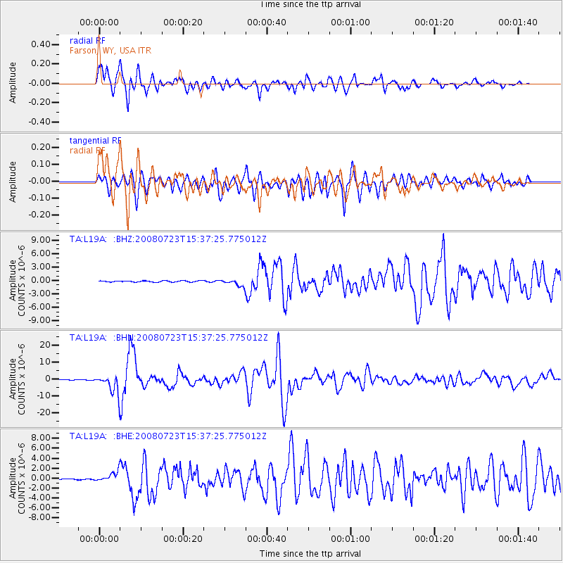
L19A Farson, WY, USA - Earthquake Result Viewer
*The percent match for this event was below the threshold and hence no stack was calculated.
| Earthquake location: |
Eastern Honshu, Japan |
| Earthquake latitude/longitude: |
39.8/141.5 |
| Earthquake time(UTC): |
2008/07/23 (205) 15:26:19 GMT |
| Earthquake Depth: |
108 km |
| Earthquake Magnitude: |
6.6 MB, 6.8 MW, 6.8 MW |
| Earthquake Catalog/Contributor: |
WHDF/NEIC |
|
| Network: |
TA USArray Transportable Network (new EarthScope stations) |
| Station: |
L19A Farson, WY, USA |
| Lat/Lon: |
42.10 N/109.36 W |
| Elevation: |
2034 m |
|
| Distance: |
76.3 deg |
| Az: |
46.353 deg |
| Baz: |
311.491 deg |
| Ray Param: |
$rayparam |
*The percent match for this event was below the threshold and hence was not used in the summary stack. |
|
| Radial Match: |
92.11663 % |
| Radial Bump: |
400 |
| Transverse Match: |
91.09356 % |
| Transverse Bump: |
400 |
| SOD ConfigId: |
2504 |
| Insert Time: |
2010-03-06 00:51:52.841 +0000 |
| GWidth: |
2.5 |
| Max Bumps: |
400 |
| Tol: |
0.001 |
|
Signal To Noise
| Channel | StoN | STA | LTA |
| TA:L19A: :BHN:20080723T15:37:25.775012Z | 36.944016 | 5.67863E-6 | 1.5370905E-7 |
| TA:L19A: :BHE:20080723T15:37:25.775012Z | 6.807157 | 1.0738762E-6 | 1.5775693E-7 |
| TA:L19A: :BHZ:20080723T15:37:25.775012Z | 5.8457427 | 7.942004E-7 | 1.3585962E-7 |
| Arrivals |
| Ps | |
| PpPs | |
| PsPs/PpSs | |


