You are here: Home > Network List > TA - USArray Transportable Network (new EarthScope stations) Stations List
> Station V20A Brimhall, NM, USA > Earthquake Result Viewer
V20A Brimhall, NM, USA - Earthquake Result Viewer
| Earthquake location: |
Kermadec Islands Region |
| Earthquake latitude/longitude: |
-31.5/-178.8 |
| Earthquake time(UTC): |
2009/05/16 (136) 00:53:52 GMT |
| Earthquake Depth: |
55 km |
| Earthquake Magnitude: |
6.1 MB, 6.5 MW, 6.3 MW |
| Earthquake Catalog/Contributor: |
WHDF/NEIC |
|
| Network: |
TA USArray Transportable Network (new EarthScope stations) |
| Station: |
V20A Brimhall, NM, USA |
| Lat/Lon: |
35.80 N/108.47 W |
| Elevation: |
1889 m |
|
| Distance: |
94.0 deg |
| Az: |
50.113 deg |
| Baz: |
233.717 deg |
| Ray Param: |
0.04112449 |
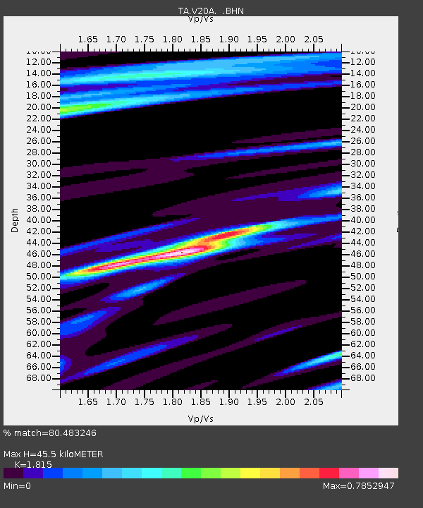
| Estimated Moho Depth: |
45.5 km |
| Estimated Crust Vp/Vs: |
1.82 |
| Assumed Crust Vp: |
6.496 km/s |
| Estimated Crust Vs: |
3.579 km/s |
| Estimated Crust Poisson's Ratio: |
0.28 |
|
| Radial Match: |
80.483246 % |
| Radial Bump: |
400 |
| Transverse Match: |
69.50231 % |
| Transverse Bump: |
400 |
| SOD ConfigId: |
2760 |
| Insert Time: |
2010-03-06 00:52:04.693 +0000 |
| GWidth: |
2.5 |
| Max Bumps: |
400 |
| Tol: |
0.001 |
|

Signal To Noise
| Channel | StoN | STA | LTA |
| TA:V20A: :BHN:20090516T01:06:33.349009Z | 9.423781 | 9.196309E-7 | 9.758619E-8 |
| TA:V20A: :BHE:20090516T01:06:33.349009Z | 0.9890791 | 1.4474347E-7 | 1.4634165E-7 |
| TA:V20A: :BHZ:20090516T01:06:33.349009Z | 1.8080049 | 2.3093291E-7 | 1.2772803E-7 |
| Arrivals |
| Ps | 5.8 SECOND |
| PpPs | 19 SECOND |
| PsPs/PpSs | 25 SECOND |


