You are here: Home > Network List > TA - USArray Transportable Network (new EarthScope stations) Stations List
> Station V20A Brimhall, NM, USA > Earthquake Result Viewer
V20A Brimhall, NM, USA - Earthquake Result Viewer
| Earthquake location: |
Tonga Islands |
| Earthquake latitude/longitude: |
-20.8/-173.3 |
| Earthquake time(UTC): |
2008/06/26 (178) 21:19:15 GMT |
| Earthquake Depth: |
38 km |
| Earthquake Magnitude: |
6.0 MB, 5.8 MS, 6.2 MW, 6.1 MW |
| Earthquake Catalog/Contributor: |
WHDF/NEIC |
|
| Network: |
TA USArray Transportable Network (new EarthScope stations) |
| Station: |
V20A Brimhall, NM, USA |
| Lat/Lon: |
35.80 N/108.47 W |
| Elevation: |
1889 m |
|
| Distance: |
83.2 deg |
| Az: |
47.831 deg |
| Baz: |
238.562 deg |
| Ray Param: |
0.046273287 |
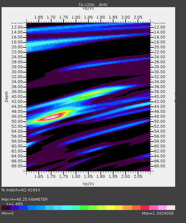
| Estimated Moho Depth: |
48.25 km |
| Estimated Crust Vp/Vs: |
1.70 |
| Assumed Crust Vp: |
6.496 km/s |
| Estimated Crust Vs: |
3.832 km/s |
| Estimated Crust Poisson's Ratio: |
0.23 |
|
| Radial Match: |
92.41943 % |
| Radial Bump: |
400 |
| Transverse Match: |
83.80326 % |
| Transverse Bump: |
400 |
| SOD ConfigId: |
2504 |
| Insert Time: |
2010-03-06 00:52:22.987 +0000 |
| GWidth: |
2.5 |
| Max Bumps: |
400 |
| Tol: |
0.001 |
|
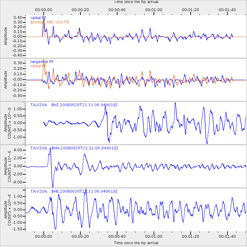
Signal To Noise
| Channel | StoN | STA | LTA |
| TA:V20A: :BHN:20080626T21:31:06.949019Z | 21.28648 | 2.0821121E-6 | 9.781384E-8 |
| TA:V20A: :BHE:20080626T21:31:06.949019Z | 3.441988 | 4.384922E-7 | 1.2739504E-7 |
| TA:V20A: :BHZ:20080626T21:31:06.949019Z | 5.867946 | 5.096331E-7 | 8.685033E-8 |
| Arrivals |
| Ps | 5.3 SECOND |
| PpPs | 19 SECOND |
| PsPs/PpSs | 25 SECOND |


