You are here: Home > Network List > TA - USArray Transportable Network (new EarthScope stations) Stations List
> Station V20A Brimhall, NM, USA > Earthquake Result Viewer
V20A Brimhall, NM, USA - Earthquake Result Viewer
| Earthquake location: |
Tonga Islands |
| Earthquake latitude/longitude: |
-21.9/-173.8 |
| Earthquake time(UTC): |
2008/10/19 (293) 05:10:33 GMT |
| Earthquake Depth: |
29 km |
| Earthquake Magnitude: |
6.8 MB, 7.0 MS, 6.9 MW, 6.9 MW |
| Earthquake Catalog/Contributor: |
WHDF/NEIC |
|
| Network: |
TA USArray Transportable Network (new EarthScope stations) |
| Station: |
V20A Brimhall, NM, USA |
| Lat/Lon: |
35.80 N/108.47 W |
| Elevation: |
1889 m |
|
| Distance: |
84.3 deg |
| Az: |
47.948 deg |
| Baz: |
238.049 deg |
| Ray Param: |
0.045546092 |
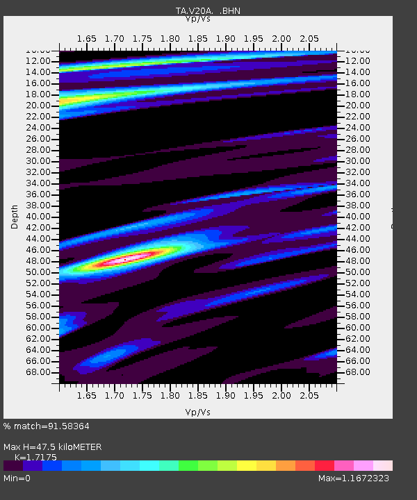
| Estimated Moho Depth: |
47.5 km |
| Estimated Crust Vp/Vs: |
1.72 |
| Assumed Crust Vp: |
6.496 km/s |
| Estimated Crust Vs: |
3.782 km/s |
| Estimated Crust Poisson's Ratio: |
0.24 |
|
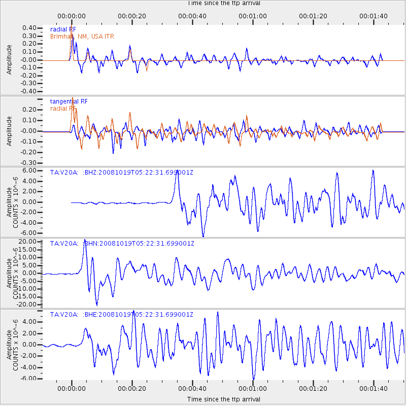
| Radial Match: |
91.58364 % |
| Radial Bump: |
400 |
| Transverse Match: |
80.59454 % |
| Transverse Bump: |
400 |
| SOD ConfigId: |
2556 |
| Insert Time: |
2010-03-06 00:52:37.943 +0000 |
| GWidth: |
2.5 |
| Max Bumps: |
400 |
| Tol: |
0.001 |
|
Signal To Noise
| Channel | StoN | STA | LTA |
| TA:V20A: :BHN:20081019T05:22:31.699001Z | 49.756966 | 8.361791E-6 | 1.6805265E-7 |
| TA:V20A: :BHE:20081019T05:22:31.699001Z | 4.2563457 | 1.1459806E-6 | 2.692405E-7 |
| TA:V20A: :BHZ:20081019T05:22:31.699001Z | 20.905207 | 1.8949148E-6 | 9.0643205E-8 |
| Arrivals |
| Ps | 5.4 SECOND |
| PpPs | 19 SECOND |
| PsPs/PpSs | 25 SECOND |


