You are here: Home > Network List > TA - USArray Transportable Network (new EarthScope stations) Stations List
> Station V20A Brimhall, NM, USA > Earthquake Result Viewer
V20A Brimhall, NM, USA - Earthquake Result Viewer
| Earthquake location: |
East Of Kuril Islands |
| Earthquake latitude/longitude: |
46.9/155.2 |
| Earthquake time(UTC): |
2009/01/15 (015) 17:49:39 GMT |
| Earthquake Depth: |
36 km |
| Earthquake Magnitude: |
6.9 MB, 7.5 MS, 7.4 MW, 7.4 MW |
| Earthquake Catalog/Contributor: |
WHDF/NEIC |
|
| Network: |
TA USArray Transportable Network (new EarthScope stations) |
| Station: |
V20A Brimhall, NM, USA |
| Lat/Lon: |
35.80 N/108.47 W |
| Elevation: |
1889 m |
|
| Distance: |
68.8 deg |
| Az: |
60.058 deg |
| Baz: |
312.987 deg |
| Ray Param: |
0.056007516 |
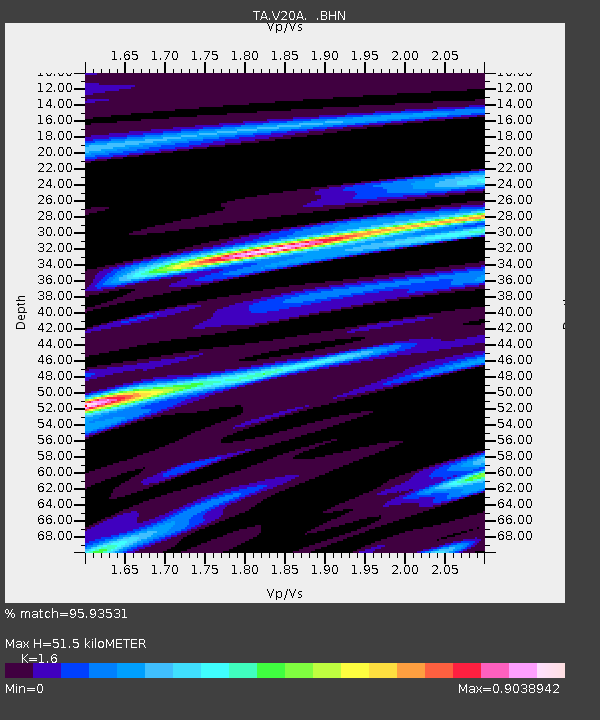
| Estimated Moho Depth: |
51.5 km |
| Estimated Crust Vp/Vs: |
1.60 |
| Assumed Crust Vp: |
6.496 km/s |
| Estimated Crust Vs: |
4.06 km/s |
| Estimated Crust Poisson's Ratio: |
0.18 |
|
| Radial Match: |
95.93531 % |
| Radial Bump: |
400 |
| Transverse Match: |
94.07539 % |
| Transverse Bump: |
328 |
| SOD ConfigId: |
2834 |
| Insert Time: |
2010-03-06 00:52:59.634 +0000 |
| GWidth: |
2.5 |
| Max Bumps: |
400 |
| Tol: |
0.001 |
|

Signal To Noise
| Channel | StoN | STA | LTA |
| TA:V20A: :BHN:20090115T18:00:08.749016Z | 53.073627 | 1.1131935E-5 | 2.0974514E-7 |
| TA:V20A: :BHE:20090115T18:00:08.749016Z | 7.6598873 | 4.6853247E-6 | 6.116702E-7 |
| TA:V20A: :BHZ:20090115T18:00:08.749016Z | 5.0901136 | 4.0752966E-6 | 8.0062983E-7 |
| Arrivals |
| Ps | 5.0 SECOND |
| PpPs | 20 SECOND |
| PsPs/PpSs | 25 SECOND |


