You are here: Home > Network List > TA - USArray Transportable Network (new EarthScope stations) Stations List
> Station V20A Brimhall, NM, USA > Earthquake Result Viewer
V20A Brimhall, NM, USA - Earthquake Result Viewer
| Earthquake location: |
Panama-Costa Rica Border Region |
| Earthquake latitude/longitude: |
8.3/-83.0 |
| Earthquake time(UTC): |
2008/11/19 (324) 06:11:20 GMT |
| Earthquake Depth: |
32 km |
| Earthquake Magnitude: |
5.9 MB, 5.9 MS, 6.2 MW, 6.1 MW |
| Earthquake Catalog/Contributor: |
WHDF/NEIC |
|
| Network: |
TA USArray Transportable Network (new EarthScope stations) |
| Station: |
V20A Brimhall, NM, USA |
| Lat/Lon: |
35.80 N/108.47 W |
| Elevation: |
1889 m |
|
| Distance: |
36.0 deg |
| Az: |
323.42 deg |
| Baz: |
133.485 deg |
| Ray Param: |
0.0768811 |
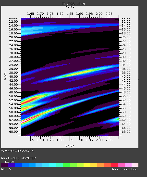
| Estimated Moho Depth: |
63.0 km |
| Estimated Crust Vp/Vs: |
1.60 |
| Assumed Crust Vp: |
6.496 km/s |
| Estimated Crust Vs: |
4.06 km/s |
| Estimated Crust Poisson's Ratio: |
0.18 |
|
| Radial Match: |
89.206795 % |
| Radial Bump: |
298 |
| Transverse Match: |
64.4682 % |
| Transverse Bump: |
400 |
| SOD ConfigId: |
2658 |
| Insert Time: |
2010-03-06 00:53:01.550 +0000 |
| GWidth: |
2.5 |
| Max Bumps: |
400 |
| Tol: |
0.001 |
|

Signal To Noise
| Channel | StoN | STA | LTA |
| TA:V20A: :BHN:20081119T06:17:48.05001Z | 2.0745723 | 4.0460125E-7 | 1.9502873E-7 |
| TA:V20A: :BHE:20081119T06:17:48.05001Z | 1.3294075 | 2.6248506E-7 | 1.9744516E-7 |
| TA:V20A: :BHZ:20081119T06:17:48.05001Z | 0.31846046 | 2.0777335E-7 | 6.5243063E-7 |
| Arrivals |
| Ps | 6.3 SECOND |
| PpPs | 23 SECOND |
| PsPs/PpSs | 29 SECOND |


