You are here: Home > Network List > TA - USArray Transportable Network (new EarthScope stations) Stations List
> Station V20A Brimhall, NM, USA > Earthquake Result Viewer
V20A Brimhall, NM, USA - Earthquake Result Viewer
| Earthquake location: |
Southeast Of Honshu, Japan |
| Earthquake latitude/longitude: |
32.8/140.4 |
| Earthquake time(UTC): |
2009/08/12 (224) 22:48:51 GMT |
| Earthquake Depth: |
53 km |
| Earthquake Magnitude: |
6.2 MB, 6.6 MW, 6.6 MW |
| Earthquake Catalog/Contributor: |
WHDF/NEIC |
|
| Network: |
TA USArray Transportable Network (new EarthScope stations) |
| Station: |
V20A Brimhall, NM, USA |
| Lat/Lon: |
35.80 N/108.47 W |
| Elevation: |
1889 m |
|
| Distance: |
86.1 deg |
| Az: |
49.46 deg |
| Baz: |
308.081 deg |
| Ray Param: |
0.044172507 |
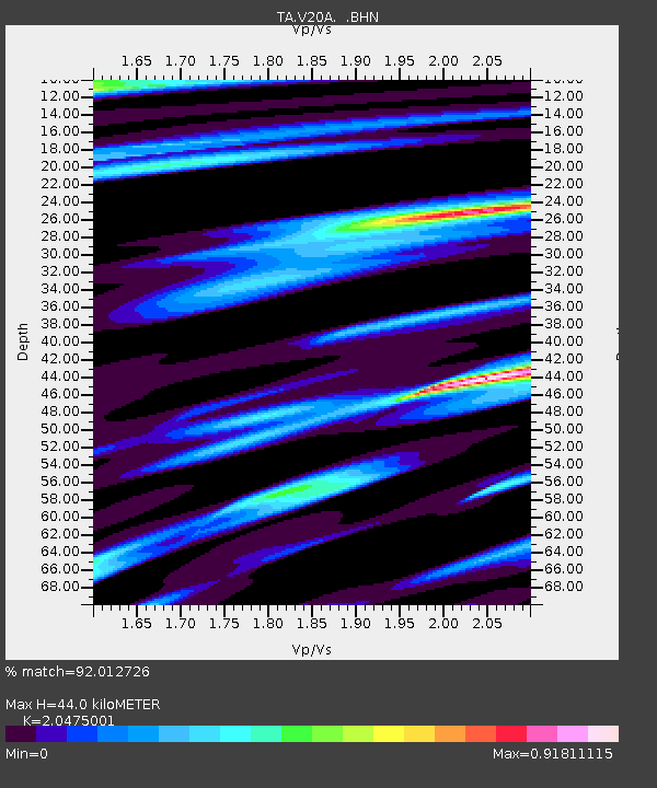
| Estimated Moho Depth: |
44.0 km |
| Estimated Crust Vp/Vs: |
2.05 |
| Assumed Crust Vp: |
6.496 km/s |
| Estimated Crust Vs: |
3.173 km/s |
| Estimated Crust Poisson's Ratio: |
0.34 |
|
| Radial Match: |
92.012726 % |
| Radial Bump: |
360 |
| Transverse Match: |
87.31017 % |
| Transverse Bump: |
345 |
| SOD ConfigId: |
2622 |
| Insert Time: |
2010-03-06 00:53:08.769 +0000 |
| GWidth: |
2.5 |
| Max Bumps: |
400 |
| Tol: |
0.001 |
|
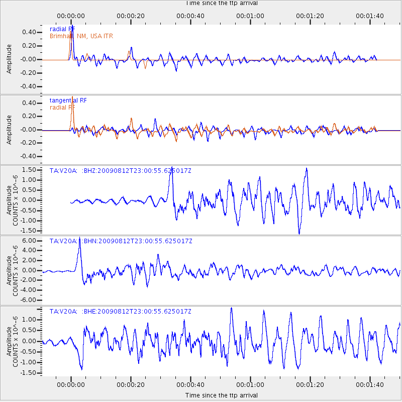
Signal To Noise
| Channel | StoN | STA | LTA |
| TA:V20A: :BHN:20090812T23:00:55.625017Z | 32.29636 | 2.4509854E-6 | 7.589046E-8 |
| TA:V20A: :BHE:20090812T23:00:55.625017Z | 6.1535406 | 5.814909E-7 | 9.4496954E-8 |
| TA:V20A: :BHZ:20090812T23:00:55.625017Z | 9.336525 | 6.6949565E-7 | 7.1707156E-8 |
| Arrivals |
| Ps | 7.2 SECOND |
| PpPs | 20 SECOND |
| PsPs/PpSs | 27 SECOND |


