You are here: Home > Network List > CI - Caltech Regional Seismic Network Stations List
> Station MPM Manuel Prospect Mine, California, USA > Earthquake Result Viewer
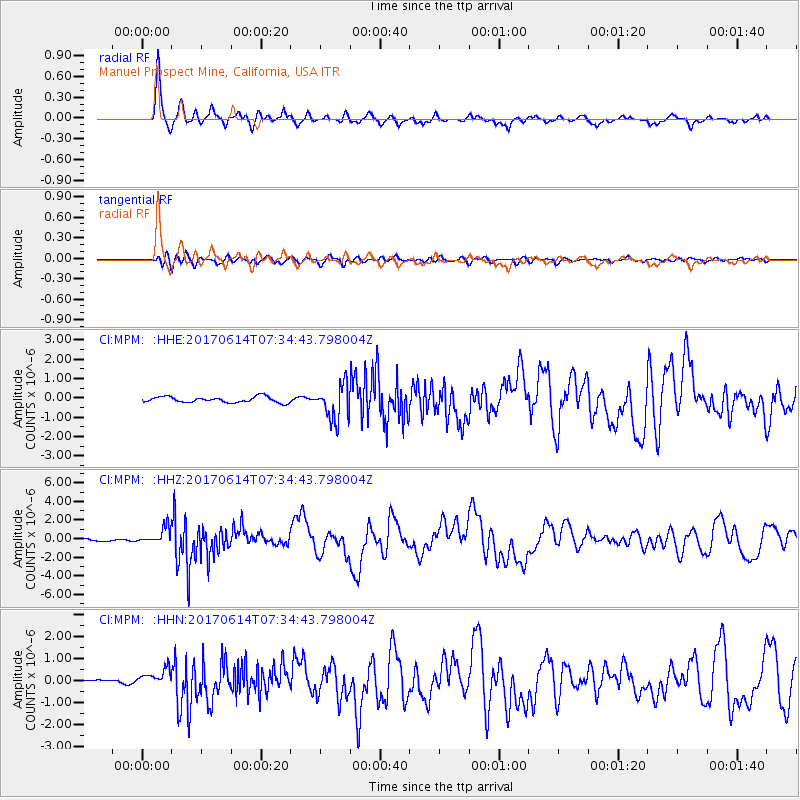
MPM Manuel Prospect Mine, California, USA - Earthquake Result Viewer
*The percent match for this event was below the threshold and hence no stack was calculated.
| Earthquake location: |
Near Coast Of Chiapas, Mexico |
| Earthquake latitude/longitude: |
14.9/-92.0 |
| Earthquake time(UTC): |
2017/06/14 (165) 07:29:03 GMT |
| Earthquake Depth: |
98 km |
| Earthquake Magnitude: |
7.0 Mi |
| Earthquake Catalog/Contributor: |
NEIC PDE/at |
|
| Network: |
CI Caltech Regional Seismic Network |
| Station: |
MPM Manuel Prospect Mine, California, USA |
| Lat/Lon: |
36.06 N/117.49 W |
| Elevation: |
185 m |
|
| Distance: |
31.0 deg |
| Az: |
317.434 deg |
| Baz: |
126.188 deg |
| Ray Param: |
$rayparam |
*The percent match for this event was below the threshold and hence was not used in the summary stack. |
|
| Radial Match: |
88.900856 % |
| Radial Bump: |
318 |
| Transverse Match: |
77.89829 % |
| Transverse Bump: |
400 |
| SOD ConfigId: |
13570011 |
| Insert Time: |
2019-04-28 05:04:16.863 +0000 |
| GWidth: |
2.5 |
| Max Bumps: |
400 |
| Tol: |
0.001 |
|
Signal To Noise
| Channel | StoN | STA | LTA |
| CI:MPM: :HHZ:20170614T07:34:43.798004Z | 7.6431756 | 9.1053386E-7 | 1.19130306E-7 |
| CI:MPM: :HHN:20170614T07:34:43.798004Z | 4.440148 | 3.7240852E-7 | 8.3873E-8 |
| CI:MPM: :HHE:20170614T07:34:43.798004Z | 3.7232013 | 5.1157076E-7 | 1.3740079E-7 |
| Arrivals |
| Ps | |
| PpPs | |
| PsPs/PpSs | |


