You are here: Home > Network List > CI - Caltech Regional Seismic Network Stations List
> Station MPP McPhearson Peak > Earthquake Result Viewer
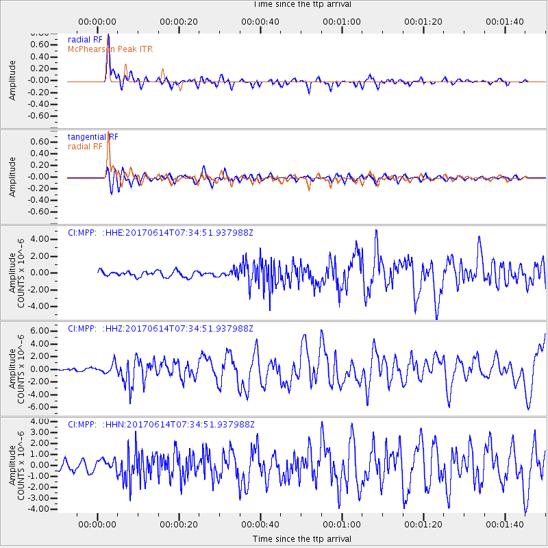
MPP McPhearson Peak - Earthquake Result Viewer
*The percent match for this event was below the threshold and hence no stack was calculated.
| Earthquake location: |
Near Coast Of Chiapas, Mexico |
| Earthquake latitude/longitude: |
14.9/-92.0 |
| Earthquake time(UTC): |
2017/06/14 (165) 07:29:03 GMT |
| Earthquake Depth: |
98 km |
| Earthquake Magnitude: |
7.0 Mi |
| Earthquake Catalog/Contributor: |
NEIC PDE/at |
|
| Network: |
CI Caltech Regional Seismic Network |
| Station: |
MPP McPhearson Peak |
| Lat/Lon: |
34.89 N/119.81 W |
| Elevation: |
1739 m |
|
| Distance: |
32.0 deg |
| Az: |
313.556 deg |
| Baz: |
121.537 deg |
| Ray Param: |
$rayparam |
*The percent match for this event was below the threshold and hence was not used in the summary stack. |
|
| Radial Match: |
88.56162 % |
| Radial Bump: |
400 |
| Transverse Match: |
64.72751 % |
| Transverse Bump: |
400 |
| SOD ConfigId: |
13570011 |
| Insert Time: |
2019-04-28 05:04:17.822 +0000 |
| GWidth: |
2.5 |
| Max Bumps: |
400 |
| Tol: |
0.001 |
|
Signal To Noise
| Channel | StoN | STA | LTA |
| CI:MPP: :HHZ:20170614T07:34:51.937988Z | 4.6563396 | 7.2984955E-7 | 1.5674318E-7 |
| CI:MPP: :HHN:20170614T07:34:51.937988Z | 1.6886146 | 5.3346935E-7 | 3.159213E-7 |
| CI:MPP: :HHE:20170614T07:34:51.937988Z | 0.5963096 | 1.964741E-7 | 3.2948338E-7 |
| Arrivals |
| Ps | |
| PpPs | |
| PsPs/PpSs | |


