You are here: Home > Network List > CI - Caltech Regional Seismic Network Stations List
> Station SHO Shoshone, CA, USA > Earthquake Result Viewer
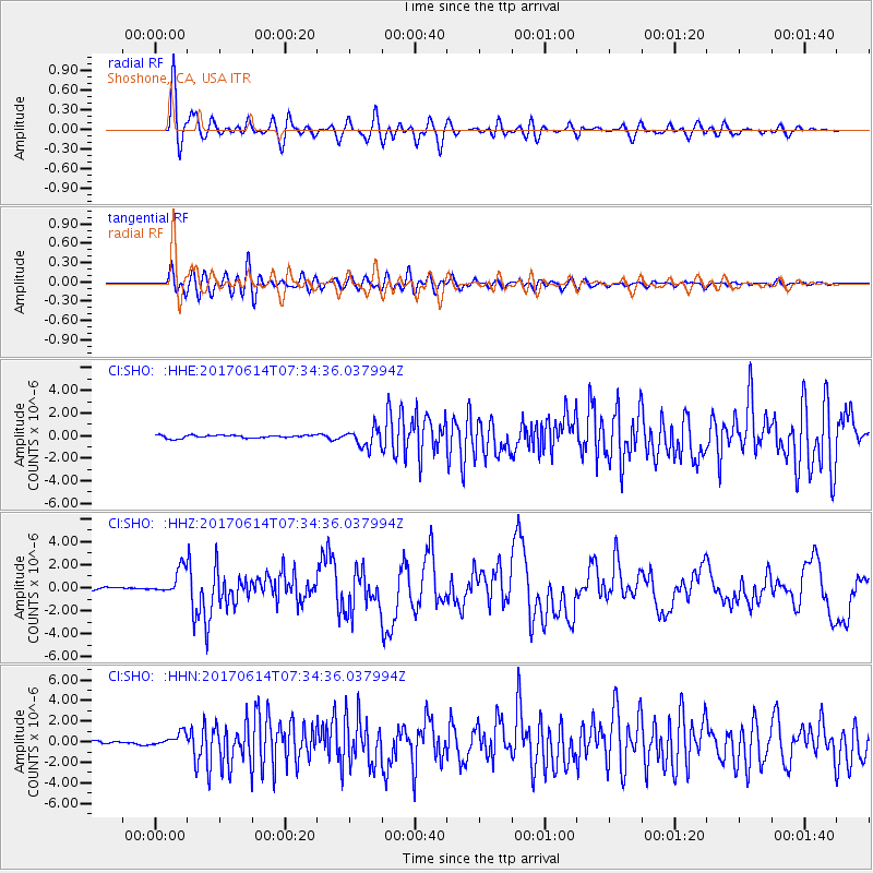
SHO Shoshone, CA, USA - Earthquake Result Viewer
*The percent match for this event was below the threshold and hence no stack was calculated.
| Earthquake location: |
Near Coast Of Chiapas, Mexico |
| Earthquake latitude/longitude: |
14.9/-92.0 |
| Earthquake time(UTC): |
2017/06/14 (165) 07:29:03 GMT |
| Earthquake Depth: |
98 km |
| Earthquake Magnitude: |
7.0 Mi |
| Earthquake Catalog/Contributor: |
NEIC PDE/at |
|
| Network: |
CI Caltech Regional Seismic Network |
| Station: |
SHO Shoshone, CA, USA |
| Lat/Lon: |
35.90 N/116.28 W |
| Elevation: |
451 m |
|
| Distance: |
30.1 deg |
| Az: |
318.349 deg |
| Baz: |
127.685 deg |
| Ray Param: |
$rayparam |
*The percent match for this event was below the threshold and hence was not used in the summary stack. |
|
| Radial Match: |
86.41596 % |
| Radial Bump: |
400 |
| Transverse Match: |
79.570366 % |
| Transverse Bump: |
400 |
| SOD ConfigId: |
13570011 |
| Insert Time: |
2019-04-28 05:04:23.463 +0000 |
| GWidth: |
2.5 |
| Max Bumps: |
400 |
| Tol: |
0.001 |
|
Signal To Noise
| Channel | StoN | STA | LTA |
| CI:SHO: :HHZ:20170614T07:34:36.037994Z | 7.645763 | 1.1358482E-6 | 1.4855917E-7 |
| CI:SHO: :HHN:20170614T07:34:36.037994Z | 3.807305 | 6.437724E-7 | 1.6908874E-7 |
| CI:SHO: :HHE:20170614T07:34:36.037994Z | 3.6486406 | 4.7257515E-7 | 1.2952088E-7 |
| Arrivals |
| Ps | |
| PpPs | |
| PsPs/PpSs | |


