You are here: Home > Network List > CI - Caltech Regional Seismic Network Stations List
> Station SMM Simmler, CA, USA > Earthquake Result Viewer
SMM Simmler, CA, USA - Earthquake Result Viewer
*The percent match for this event was below the threshold and hence no stack was calculated.
| Earthquake location: |
Near Coast Of Chiapas, Mexico |
| Earthquake latitude/longitude: |
14.9/-92.0 |
| Earthquake time(UTC): |
2017/06/14 (165) 07:29:03 GMT |
| Earthquake Depth: |
98 km |
| Earthquake Magnitude: |
7.0 Mi |
| Earthquake Catalog/Contributor: |
NEIC PDE/at |
|
| Network: |
CI Caltech Regional Seismic Network |
| Station: |
SMM Simmler, CA, USA |
| Lat/Lon: |
35.31 N/120.00 W |
| Elevation: |
599 m |
|
| Distance: |
32.3 deg |
| Az: |
314.087 deg |
| Baz: |
121.883 deg |
| Ray Param: |
$rayparam |
*The percent match for this event was below the threshold and hence was not used in the summary stack. |
|
| Radial Match: |
86.7287 % |
| Radial Bump: |
400 |
| Transverse Match: |
74.83188 % |
| Transverse Bump: |
400 |
| SOD ConfigId: |
13570011 |
| Insert Time: |
2019-04-28 05:04:24.047 +0000 |
| GWidth: |
2.5 |
| Max Bumps: |
400 |
| Tol: |
0.001 |
|
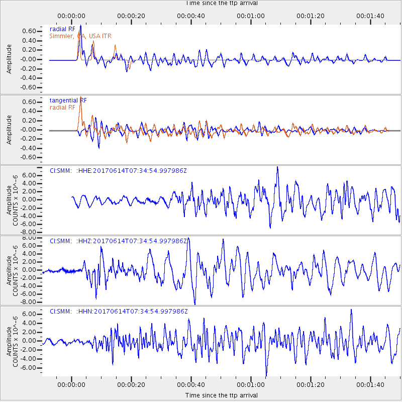
Signal To Noise
| Channel | StoN | STA | LTA |
| CI:SMM: :HHZ:20170614T07:34:54.997986Z | 2.8715904 | 7.741221E-7 | 2.6957957E-7 |
| CI:SMM: :HHN:20170614T07:34:54.997986Z | 0.6322014 | 2.9967612E-7 | 4.7402003E-7 |
| CI:SMM: :HHE:20170614T07:34:54.997986Z | 0.89160866 | 6.99937E-7 | 7.850271E-7 |
| Arrivals |
| Ps | |
| PpPs | |
| PsPs/PpSs | |


