You are here: Home > Network List > CN - Canadian National Seismograph Network Stations List
> Station INK INUVIK, NT > Earthquake Result Viewer
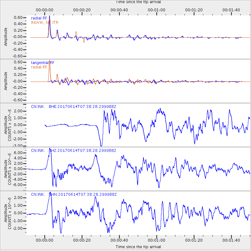
INK INUVIK, NT - Earthquake Result Viewer
*The percent match for this event was below the threshold and hence no stack was calculated.
| Earthquake location: |
Near Coast Of Chiapas, Mexico |
| Earthquake latitude/longitude: |
14.9/-92.0 |
| Earthquake time(UTC): |
2017/06/14 (165) 07:29:03 GMT |
| Earthquake Depth: |
98 km |
| Earthquake Magnitude: |
7.0 Mi |
| Earthquake Catalog/Contributor: |
NEIC PDE/at |
|
| Network: |
CN Canadian National Seismograph Network |
| Station: |
INK INUVIK, NT |
| Lat/Lon: |
68.31 N/133.53 W |
| Elevation: |
44 m |
|
| Distance: |
59.6 deg |
| Az: |
343.392 deg |
| Baz: |
131.991 deg |
| Ray Param: |
$rayparam |
*The percent match for this event was below the threshold and hence was not used in the summary stack. |
|
| Radial Match: |
97.261566 % |
| Radial Bump: |
312 |
| Transverse Match: |
82.009834 % |
| Transverse Bump: |
400 |
| SOD ConfigId: |
13570011 |
| Insert Time: |
2019-04-28 05:04:58.444 +0000 |
| GWidth: |
2.5 |
| Max Bumps: |
400 |
| Tol: |
0.001 |
|
Signal To Noise
| Channel | StoN | STA | LTA |
| CN:INK: :BHZ:20170614T07:38:28.299988Z | 17.220234 | 4.062883E-6 | 2.3593657E-7 |
| CN:INK: :BHN:20170614T07:38:28.299988Z | 20.253048 | 1.4655549E-6 | 7.2362184E-8 |
| CN:INK: :BHE:20170614T07:38:28.299988Z | 15.247056 | 1.6019609E-6 | 1.050669E-7 |
| Arrivals |
| Ps | |
| PpPs | |
| PsPs/PpSs | |


