You are here: Home > Network List > TA - USArray Transportable Network (new EarthScope stations) Stations List
> Station V20A Brimhall, NM, USA > Earthquake Result Viewer
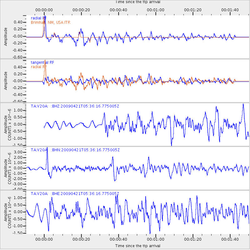
V20A Brimhall, NM, USA - Earthquake Result Viewer
*The percent match for this event was below the threshold and hence no stack was calculated.
| Earthquake location: |
Kuril Islands |
| Earthquake latitude/longitude: |
50.8/155.0 |
| Earthquake time(UTC): |
2009/04/21 (111) 05:26:11 GMT |
| Earthquake Depth: |
152 km |
| Earthquake Magnitude: |
6.0 MB, 6.2 MW, 6.2 MW |
| Earthquake Catalog/Contributor: |
WHDF/NEIC |
|
| Network: |
TA USArray Transportable Network (new EarthScope stations) |
| Station: |
V20A Brimhall, NM, USA |
| Lat/Lon: |
35.80 N/108.47 W |
| Elevation: |
1889 m |
|
| Distance: |
66.9 deg |
| Az: |
61.38 deg |
| Baz: |
316.784 deg |
| Ray Param: |
$rayparam |
*The percent match for this event was below the threshold and hence was not used in the summary stack. |
|
| Radial Match: |
73.68134 % |
| Radial Bump: |
355 |
| Transverse Match: |
58.882244 % |
| Transverse Bump: |
371 |
| SOD ConfigId: |
2760 |
| Insert Time: |
2010-03-06 00:54:09.624 +0000 |
| GWidth: |
2.5 |
| Max Bumps: |
400 |
| Tol: |
0.001 |
|
Signal To Noise
| Channel | StoN | STA | LTA |
| TA:V20A: :BHN:20090421T05:36:16.775005Z | 8.067847 | 1.329894E-6 | 1.6483877E-7 |
| TA:V20A: :BHE:20090421T05:36:16.775005Z | 2.3306017 | 5.891046E-7 | 2.5276933E-7 |
| TA:V20A: :BHZ:20090421T05:36:16.775005Z | 2.7046397 | 3.945452E-7 | 1.4587718E-7 |
| Arrivals |
| Ps | |
| PpPs | |
| PsPs/PpSs | |


