You are here: Home > Network List > GT - Global Telemetered Seismograph Network (USAF/USGS) Stations List
> Station PLCA Paso Flores, Argentina > Earthquake Result Viewer
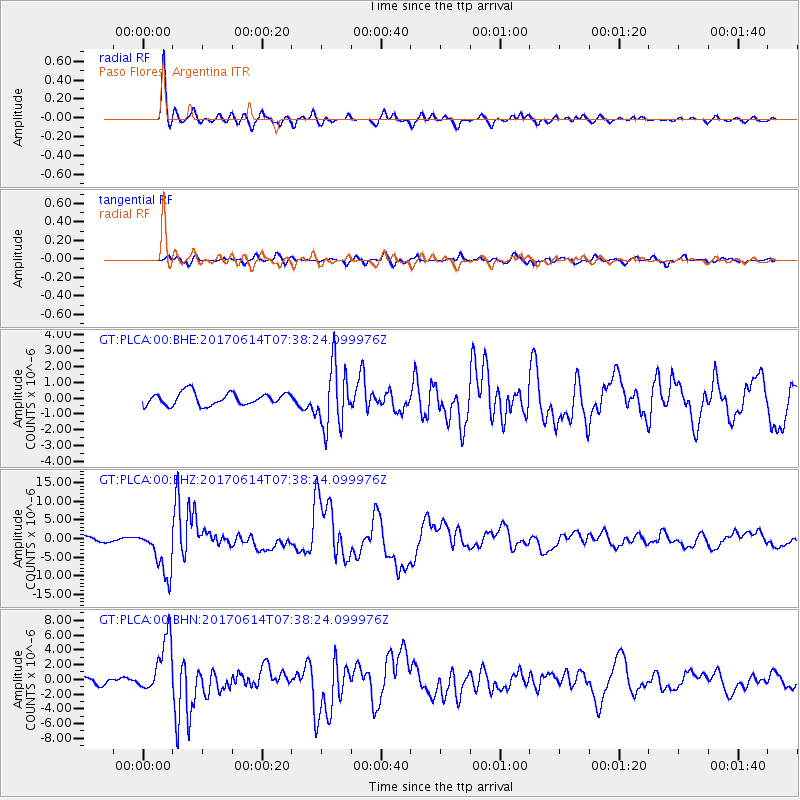
PLCA Paso Flores, Argentina - Earthquake Result Viewer
*The percent match for this event was below the threshold and hence no stack was calculated.
| Earthquake location: |
Near Coast Of Chiapas, Mexico |
| Earthquake latitude/longitude: |
14.9/-92.0 |
| Earthquake time(UTC): |
2017/06/14 (165) 07:29:03 GMT |
| Earthquake Depth: |
98 km |
| Earthquake Magnitude: |
7.0 Mi |
| Earthquake Catalog/Contributor: |
NEIC PDE/at |
|
| Network: |
GT Global Telemetered Seismograph Network (USAF/USGS) |
| Station: |
PLCA Paso Flores, Argentina |
| Lat/Lon: |
40.73 S/70.55 W |
| Elevation: |
1050 m |
|
| Distance: |
58.8 deg |
| Az: |
161.046 deg |
| Baz: |
335.592 deg |
| Ray Param: |
$rayparam |
*The percent match for this event was below the threshold and hence was not used in the summary stack. |
|
| Radial Match: |
92.54455 % |
| Radial Bump: |
348 |
| Transverse Match: |
81.27737 % |
| Transverse Bump: |
400 |
| SOD ConfigId: |
13570011 |
| Insert Time: |
2019-04-28 05:06:27.219 +0000 |
| GWidth: |
2.5 |
| Max Bumps: |
400 |
| Tol: |
0.001 |
|
Signal To Noise
| Channel | StoN | STA | LTA |
| GT:PLCA:00:BHZ:20170614T07:38:24.099976Z | 9.999035 | 6.3171947E-6 | 6.3178044E-7 |
| GT:PLCA:00:BHN:20170614T07:38:24.099976Z | 9.533794 | 3.7545778E-6 | 3.938178E-7 |
| GT:PLCA:00:BHE:20170614T07:38:24.099976Z | 2.8908496 | 1.1850947E-6 | 4.0994684E-7 |
| Arrivals |
| Ps | |
| PpPs | |
| PsPs/PpSs | |


