You are here: Home > Network List > TA - USArray Transportable Network (new EarthScope stations) Stations List
> Station V20A Brimhall, NM, USA > Earthquake Result Viewer
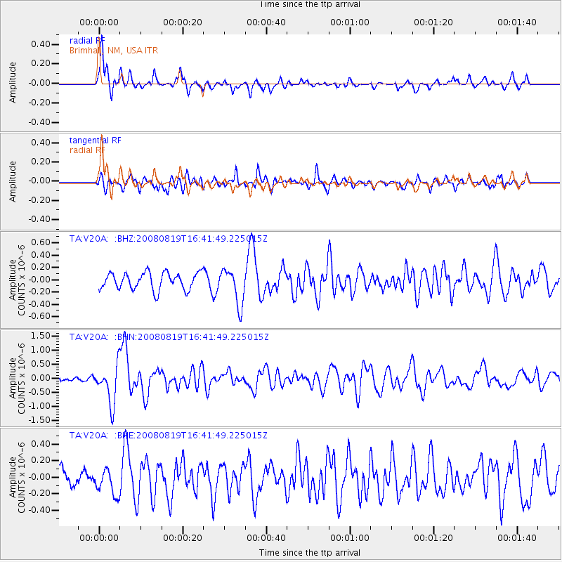
V20A Brimhall, NM, USA - Earthquake Result Viewer
*The percent match for this event was below the threshold and hence no stack was calculated.
| Earthquake location: |
Tonga Islands |
| Earthquake latitude/longitude: |
-15.1/-173.5 |
| Earthquake time(UTC): |
2008/08/19 (232) 16:30:13 GMT |
| Earthquake Depth: |
8.0 km |
| Earthquake Magnitude: |
5.6 MB, 5.9 MS, 6.1 MW, 6.0 MW |
| Earthquake Catalog/Contributor: |
WHDF/NEIC |
|
| Network: |
TA USArray Transportable Network (new EarthScope stations) |
| Station: |
V20A Brimhall, NM, USA |
| Lat/Lon: |
35.80 N/108.47 W |
| Elevation: |
1889 m |
|
| Distance: |
79.6 deg |
| Az: |
48.522 deg |
| Baz: |
242.906 deg |
| Ray Param: |
$rayparam |
*The percent match for this event was below the threshold and hence was not used in the summary stack. |
|
| Radial Match: |
77.52329 % |
| Radial Bump: |
297 |
| Transverse Match: |
68.3588 % |
| Transverse Bump: |
400 |
| SOD ConfigId: |
2504 |
| Insert Time: |
2010-03-06 00:54:57.793 +0000 |
| GWidth: |
2.5 |
| Max Bumps: |
400 |
| Tol: |
0.001 |
|
Signal To Noise
| Channel | StoN | STA | LTA |
| TA:V20A: :BHN:20080819T16:41:49.225015Z | 9.529414 | 7.0860796E-7 | 7.4360074E-8 |
| TA:V20A: :BHE:20080819T16:41:49.225015Z | 2.1442206 | 1.629438E-7 | 7.599209E-8 |
| TA:V20A: :BHZ:20080819T16:41:49.225015Z | 2.211833 | 3.0058177E-7 | 1.3589714E-7 |
| Arrivals |
| Ps | |
| PpPs | |
| PsPs/PpSs | |


