You are here: Home > Network List > TA - USArray Transportable Network (new EarthScope stations) Stations List
> Station D23K Nanushuk River, AK USA > Earthquake Result Viewer
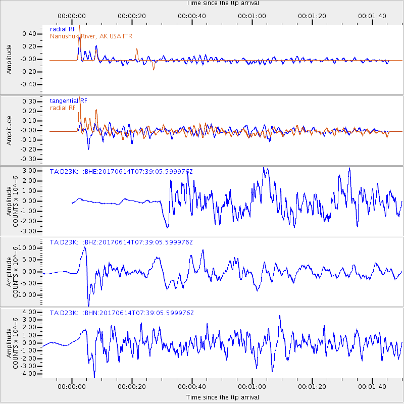
D23K Nanushuk River, AK USA - Earthquake Result Viewer
*The percent match for this event was below the threshold and hence no stack was calculated.
| Earthquake location: |
Near Coast Of Chiapas, Mexico |
| Earthquake latitude/longitude: |
14.9/-92.0 |
| Earthquake time(UTC): |
2017/06/14 (165) 07:29:03 GMT |
| Earthquake Depth: |
98 km |
| Earthquake Magnitude: |
7.0 Mi |
| Earthquake Catalog/Contributor: |
NEIC PDE/at |
|
| Network: |
TA USArray Transportable Network (new EarthScope stations) |
| Station: |
D23K Nanushuk River, AK USA |
| Lat/Lon: |
68.97 N/150.68 W |
| Elevation: |
406 m |
|
| Distance: |
65.2 deg |
| Az: |
340.135 deg |
| Baz: |
114.5 deg |
| Ray Param: |
$rayparam |
*The percent match for this event was below the threshold and hence was not used in the summary stack. |
|
| Radial Match: |
89.521454 % |
| Radial Bump: |
400 |
| Transverse Match: |
83.90826 % |
| Transverse Bump: |
400 |
| SOD ConfigId: |
13570011 |
| Insert Time: |
2019-04-28 05:09:00.806 +0000 |
| GWidth: |
2.5 |
| Max Bumps: |
400 |
| Tol: |
0.001 |
|
Signal To Noise
| Channel | StoN | STA | LTA |
| TA:D23K: :BHZ:20170614T07:39:05.599976Z | 21.266378 | 5.2921773E-6 | 2.4885185E-7 |
| TA:D23K: :BHN:20170614T07:39:05.599976Z | 3.547404 | 1.0239405E-6 | 2.88645E-7 |
| TA:D23K: :BHE:20170614T07:39:05.599976Z | 7.6839767 | 1.2324439E-6 | 1.6039142E-7 |
| Arrivals |
| Ps | |
| PpPs | |
| PsPs/PpSs | |


