You are here: Home > Network List > TA - USArray Transportable Network (new EarthScope stations) Stations List
> Station F21K Alatna River, AK, USA > Earthquake Result Viewer
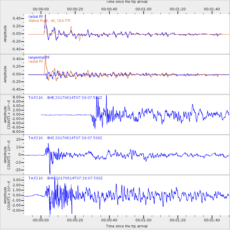
F21K Alatna River, AK, USA - Earthquake Result Viewer
*The percent match for this event was below the threshold and hence no stack was calculated.
| Earthquake location: |
Near Coast Of Chiapas, Mexico |
| Earthquake latitude/longitude: |
14.9/-92.0 |
| Earthquake time(UTC): |
2017/06/14 (165) 07:29:03 GMT |
| Earthquake Depth: |
98 km |
| Earthquake Magnitude: |
7.0 Mi |
| Earthquake Catalog/Contributor: |
NEIC PDE/at |
|
| Network: |
TA USArray Transportable Network (new EarthScope stations) |
| Station: |
F21K Alatna River, AK, USA |
| Lat/Lon: |
67.22 N/153.48 W |
| Elevation: |
597 m |
|
| Distance: |
65.5 deg |
| Az: |
337.91 deg |
| Baz: |
110.974 deg |
| Ray Param: |
$rayparam |
*The percent match for this event was below the threshold and hence was not used in the summary stack. |
|
| Radial Match: |
97.64688 % |
| Radial Bump: |
400 |
| Transverse Match: |
89.200035 % |
| Transverse Bump: |
400 |
| SOD ConfigId: |
13570011 |
| Insert Time: |
2019-04-28 05:09:06.836 +0000 |
| GWidth: |
2.5 |
| Max Bumps: |
400 |
| Tol: |
0.001 |
|
Signal To Noise
| Channel | StoN | STA | LTA |
| TA:F21K: :BHZ:20170614T07:39:07.500Z | 38.529358 | 4.8495926E-6 | 1.2586747E-7 |
| TA:F21K: :BHN:20170614T07:39:07.500Z | 8.034489 | 6.8203104E-7 | 8.488793E-8 |
| TA:F21K: :BHE:20170614T07:39:07.500Z | 35.662075 | 2.0365562E-6 | 5.7107062E-8 |
| Arrivals |
| Ps | |
| PpPs | |
| PsPs/PpSs | |


