You are here: Home > Network List > TA - USArray Transportable Network (new EarthScope stations) Stations List
> Station V20A Brimhall, NM, USA > Earthquake Result Viewer
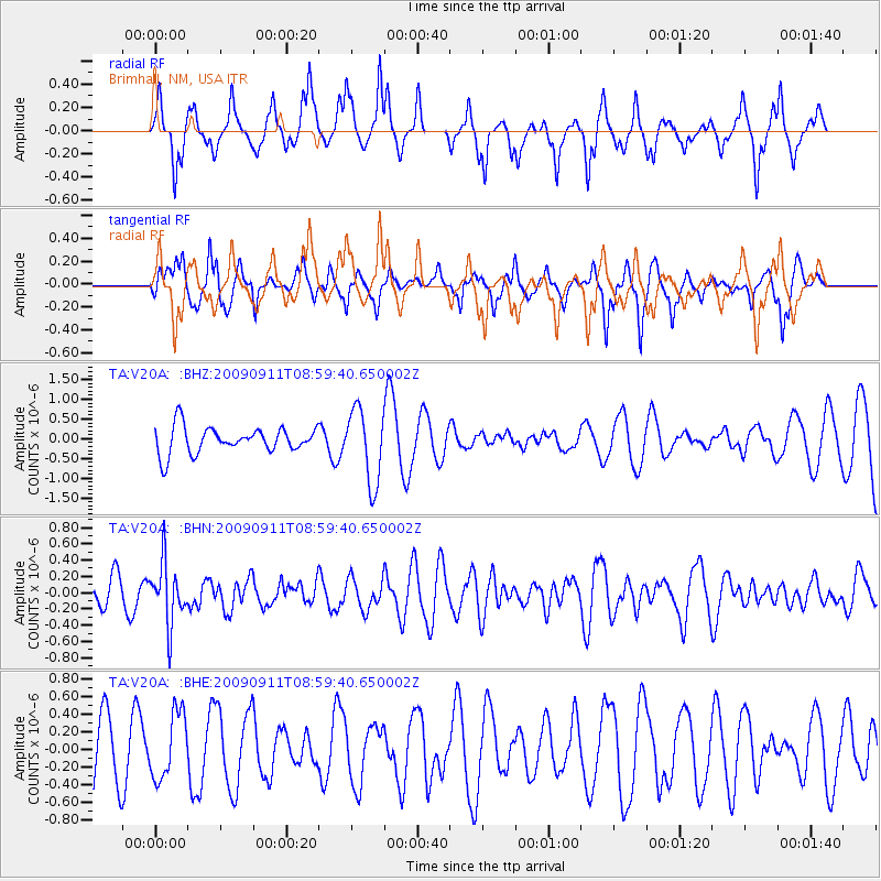
V20A Brimhall, NM, USA - Earthquake Result Viewer
*The percent match for this event was below the threshold and hence no stack was calculated.
| Earthquake location: |
Kuril Islands |
| Earthquake latitude/longitude: |
48.3/154.2 |
| Earthquake time(UTC): |
2009/09/11 (254) 08:49:11 GMT |
| Earthquake Depth: |
35 km |
| Earthquake Magnitude: |
5.8 MB, 5.0 MS, 5.6 MW, 5.6 MW |
| Earthquake Catalog/Contributor: |
WHDF/NEIC |
|
| Network: |
TA USArray Transportable Network (new EarthScope stations) |
| Station: |
V20A Brimhall, NM, USA |
| Lat/Lon: |
35.80 N/108.47 W |
| Elevation: |
1889 m |
|
| Distance: |
68.6 deg |
| Az: |
59.985 deg |
| Baz: |
314.659 deg |
| Ray Param: |
$rayparam |
*The percent match for this event was below the threshold and hence was not used in the summary stack. |
|
| Radial Match: |
49.302544 % |
| Radial Bump: |
266 |
| Transverse Match: |
58.884735 % |
| Transverse Bump: |
327 |
| SOD ConfigId: |
2622 |
| Insert Time: |
2010-03-06 00:55:27.494 +0000 |
| GWidth: |
2.5 |
| Max Bumps: |
400 |
| Tol: |
0.001 |
|
Signal To Noise
| Channel | StoN | STA | LTA |
| TA:V20A: :BHN:20090911T08:59:40.650002Z | 1.9014763 | 3.716743E-7 | 1.9546619E-7 |
| TA:V20A: :BHE:20090911T08:59:40.650002Z | 0.7780274 | 3.7429334E-7 | 4.810799E-7 |
| TA:V20A: :BHZ:20090911T08:59:40.650002Z | 2.7927346 | 9.293425E-7 | 3.327715E-7 |
| Arrivals |
| Ps | |
| PpPs | |
| PsPs/PpSs | |


