You are here: Home > Network List > AU - Australian Seismological Centre Stations List
> Station PSAB1 Pilbara Seismic Array Element B1 > Earthquake Result Viewer
PSAB1 Pilbara Seismic Array Element B1 - Earthquake Result Viewer
| Earthquake location: |
Western Indian-Antarctic Ridge |
| Earthquake latitude/longitude: |
-50.6/139.4 |
| Earthquake time(UTC): |
2016/01/01 (001) 02:00:39 GMT |
| Earthquake Depth: |
10 km |
| Earthquake Magnitude: |
6.3 MWP |
| Earthquake Catalog/Contributor: |
NEIC PDE/NEIC COMCAT |
|
| Network: |
AU Australian Seismological Centre |
| Station: |
PSAB1 Pilbara Seismic Array Element B1 |
| Lat/Lon: |
21.57 S/119.82 E |
| Elevation: |
317 m |
|
| Distance: |
32.8 deg |
| Az: |
324.751 deg |
| Baz: |
156.713 deg |
| Ray Param: |
0.078498356 |
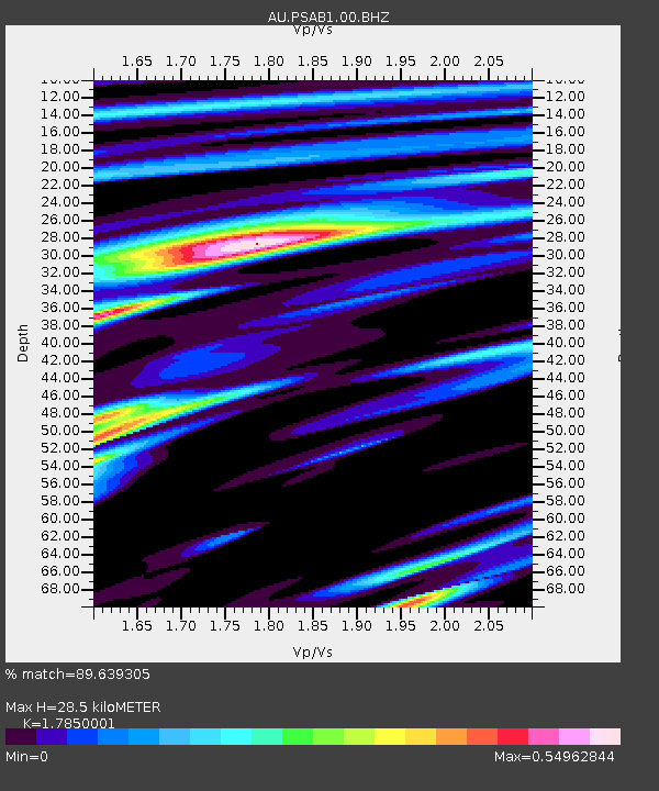
| Estimated Moho Depth: |
28.5 km |
| Estimated Crust Vp/Vs: |
1.79 |
| Assumed Crust Vp: |
6.464 km/s |
| Estimated Crust Vs: |
3.621 km/s |
| Estimated Crust Poisson's Ratio: |
0.27 |
|
| Radial Match: |
89.639305 % |
| Radial Bump: |
260 |
| Transverse Match: |
78.55735 % |
| Transverse Bump: |
370 |
| SOD ConfigId: |
1379111 |
| Insert Time: |
2016-01-15 02:31:39.237 +0000 |
| GWidth: |
2.5 |
| Max Bumps: |
400 |
| Tol: |
0.001 |
|

Signal To Noise
| Channel | StoN | STA | LTA |
| AU:PSAB1:00:BHZ:20160101T02:06:42.543993Z | 8.748246 | 2.2940783E-6 | 2.6223293E-7 |
| AU:PSAB1:00:BH1:20160101T02:06:42.543993Z | 3.1069596 | 4.8296283E-7 | 1.5544548E-7 |
| AU:PSAB1:00:BH2:20160101T02:06:42.543993Z | 9.1611595 | 1.3531961E-6 | 1.4771014E-7 |
| Arrivals |
| Ps | 3.7 SECOND |
| PpPs | 11 SECOND |
| PsPs/PpSs | 15 SECOND |


