You are here: Home > Network List > AU - Australian Seismological Centre Stations List
> Station PSAD3 Pilbara Seismic Array Element D3 > Earthquake Result Viewer
PSAD3 Pilbara Seismic Array Element D3 - Earthquake Result Viewer
| Earthquake location: |
Western Indian-Antarctic Ridge |
| Earthquake latitude/longitude: |
-50.6/139.4 |
| Earthquake time(UTC): |
2016/01/01 (001) 02:00:39 GMT |
| Earthquake Depth: |
10 km |
| Earthquake Magnitude: |
6.3 MWP |
| Earthquake Catalog/Contributor: |
NEIC PDE/NEIC COMCAT |
|
| Network: |
AU Australian Seismological Centre |
| Station: |
PSAD3 Pilbara Seismic Array Element D3 |
| Lat/Lon: |
21.64 S/119.78 E |
| Elevation: |
327 m |
|
| Distance: |
32.7 deg |
| Az: |
324.631 deg |
| Baz: |
156.627 deg |
| Ray Param: |
0.07852056 |
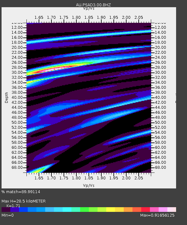
| Estimated Moho Depth: |
28.5 km |
| Estimated Crust Vp/Vs: |
1.71 |
| Assumed Crust Vp: |
6.464 km/s |
| Estimated Crust Vs: |
3.78 km/s |
| Estimated Crust Poisson's Ratio: |
0.24 |
|
| Radial Match: |
89.99114 % |
| Radial Bump: |
313 |
| Transverse Match: |
64.21112 % |
| Transverse Bump: |
400 |
| SOD ConfigId: |
1379111 |
| Insert Time: |
2016-01-15 02:33:04.458 +0000 |
| GWidth: |
2.5 |
| Max Bumps: |
400 |
| Tol: |
0.001 |
|

Signal To Noise
| Channel | StoN | STA | LTA |
| AU:PSAD3:00:BHZ:20160101T02:06:42.094011Z | 8.7959175 | 2.1760725E-6 | 2.4739575E-7 |
| AU:PSAD3:00:BH1:20160101T02:06:42.094011Z | 10.73581 | 1.4944093E-6 | 1.3919855E-7 |
| AU:PSAD3:00:BH2:20160101T02:06:42.094011Z | 1.897541 | 2.6441325E-7 | 1.3934519E-7 |
| Arrivals |
| Ps | 3.4 SECOND |
| PpPs | 11 SECOND |
| PsPs/PpSs | 14 SECOND |


