You are here: Home > Network List > GT - Global Telemetered Seismograph Network (USAF/USGS) Stations List
> Station BOSA Boshof, South Africa > Earthquake Result Viewer
BOSA Boshof, South Africa - Earthquake Result Viewer
| Earthquake location: |
Western Indian-Antarctic Ridge |
| Earthquake latitude/longitude: |
-50.6/139.4 |
| Earthquake time(UTC): |
2016/01/01 (001) 02:00:39 GMT |
| Earthquake Depth: |
10 km |
| Earthquake Magnitude: |
6.3 MWP |
| Earthquake Catalog/Contributor: |
NEIC PDE/NEIC COMCAT |
|
| Network: |
GT Global Telemetered Seismograph Network (USAF/USGS) |
| Station: |
BOSA Boshof, South Africa |
| Lat/Lon: |
28.61 S/25.26 E |
| Elevation: |
1280 m |
|
| Distance: |
82.1 deg |
| Az: |
234.064 deg |
| Baz: |
144.043 deg |
| Ray Param: |
0.047115758 |
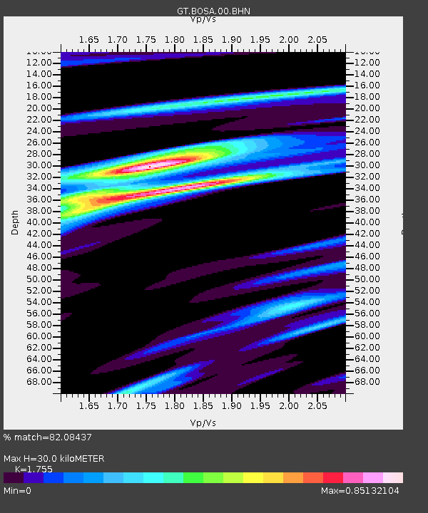
| Estimated Moho Depth: |
30.0 km |
| Estimated Crust Vp/Vs: |
1.75 |
| Assumed Crust Vp: |
6.459 km/s |
| Estimated Crust Vs: |
3.681 km/s |
| Estimated Crust Poisson's Ratio: |
0.26 |
|
| Radial Match: |
82.08437 % |
| Radial Bump: |
325 |
| Transverse Match: |
66.57396 % |
| Transverse Bump: |
393 |
| SOD ConfigId: |
1379111 |
| Insert Time: |
2016-01-15 02:40:52.432 +0000 |
| GWidth: |
2.5 |
| Max Bumps: |
400 |
| Tol: |
0.001 |
|
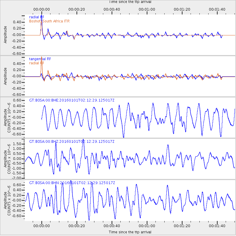
Signal To Noise
| Channel | StoN | STA | LTA |
| GT:BOSA:00:BHZ:20160101T02:12:29.125017Z | 3.7031968 | 6.1676656E-7 | 1.6654975E-7 |
| GT:BOSA:00:BHN:20160101T02:12:29.125017Z | 1.3367515 | 2.295985E-7 | 1.7175856E-7 |
| GT:BOSA:00:BHE:20160101T02:12:29.125017Z | 1.2339153 | 2.9164985E-7 | 2.3636134E-7 |
| Arrivals |
| Ps | 3.6 SECOND |
| PpPs | 12 SECOND |
| PsPs/PpSs | 16 SECOND |


