You are here: Home > Network List > TA - USArray Transportable Network (new EarthScope stations) Stations List
> Station V20A Brimhall, NM, USA > Earthquake Result Viewer
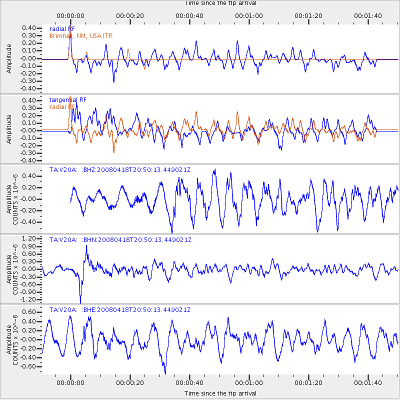
V20A Brimhall, NM, USA - Earthquake Result Viewer
*The percent match for this event was below the threshold and hence no stack was calculated.
| Earthquake location: |
Fiji Islands Region |
| Earthquake latitude/longitude: |
-17.3/-179.0 |
| Earthquake time(UTC): |
2008/04/18 (109) 20:39:07 GMT |
| Earthquake Depth: |
554 km |
| Earthquake Magnitude: |
5.9 MB, 6.3 MW, 6.3 MW |
| Earthquake Catalog/Contributor: |
WHDF/NEIC |
|
| Network: |
TA USArray Transportable Network (new EarthScope stations) |
| Station: |
V20A Brimhall, NM, USA |
| Lat/Lon: |
35.80 N/108.47 W |
| Elevation: |
1889 m |
|
| Distance: |
85.1 deg |
| Az: |
50.301 deg |
| Baz: |
244.686 deg |
| Ray Param: |
$rayparam |
*The percent match for this event was below the threshold and hence was not used in the summary stack. |
|
| Radial Match: |
48.959194 % |
| Radial Bump: |
391 |
| Transverse Match: |
51.409225 % |
| Transverse Bump: |
400 |
| SOD ConfigId: |
2504 |
| Insert Time: |
2010-03-06 00:56:45.314 +0000 |
| GWidth: |
2.5 |
| Max Bumps: |
400 |
| Tol: |
0.001 |
|
Signal To Noise
| Channel | StoN | STA | LTA |
| TA:V20A: :BHN:20080418T20:50:13.449021Z | 3.108188 | 4.0602455E-7 | 1.3063062E-7 |
| TA:V20A: :BHE:20080418T20:50:13.449021Z | 1.3987163 | 3.005437E-7 | 2.1487108E-7 |
| TA:V20A: :BHZ:20080418T20:50:13.449021Z | 2.523606 | 2.7802457E-7 | 1.1016956E-7 |
| Arrivals |
| Ps | |
| PpPs | |
| PsPs/PpSs | |


