You are here: Home > Network List > TA - USArray Transportable Network (new EarthScope stations) Stations List
> Station V20A Brimhall, NM, USA > Earthquake Result Viewer
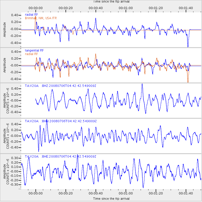
V20A Brimhall, NM, USA - Earthquake Result Viewer
*The percent match for this event was below the threshold and hence no stack was calculated.
| Earthquake location: |
South Of Fiji Islands |
| Earthquake latitude/longitude: |
-25.5/-176.4 |
| Earthquake time(UTC): |
2008/07/06 (188) 04:30:26 GMT |
| Earthquake Depth: |
49 km |
| Earthquake Magnitude: |
5.5 MB, 5.3 MS |
| Earthquake Catalog/Contributor: |
WHDF/NEIC |
|
| Network: |
TA USArray Transportable Network (new EarthScope stations) |
| Station: |
V20A Brimhall, NM, USA |
| Lat/Lon: |
35.80 N/108.47 W |
| Elevation: |
1889 m |
|
| Distance: |
88.4 deg |
| Az: |
48.887 deg |
| Baz: |
236.911 deg |
| Ray Param: |
$rayparam |
*The percent match for this event was below the threshold and hence was not used in the summary stack. |
|
| Radial Match: |
61.019054 % |
| Radial Bump: |
400 |
| Transverse Match: |
59.93081 % |
| Transverse Bump: |
397 |
| SOD ConfigId: |
2504 |
| Insert Time: |
2010-03-06 00:56:59.395 +0000 |
| GWidth: |
2.5 |
| Max Bumps: |
400 |
| Tol: |
0.001 |
|
Signal To Noise
| Channel | StoN | STA | LTA |
| TA:V20A: :BHN:20080706T04:42:42.549009Z | 2.1001265 | 2.2025554E-7 | 1.0487727E-7 |
| TA:V20A: :BHE:20080706T04:42:42.549009Z | 0.38225463 | 4.7689362E-8 | 1.247581E-7 |
| TA:V20A: :BHZ:20080706T04:42:42.549009Z | 1.2852241 | 2.1041275E-7 | 1.6371678E-7 |
| Arrivals |
| Ps | |
| PpPs | |
| PsPs/PpSs | |


