You are here: Home > Network List > CC - Cascade Chain Volcano Monitoring Stations List
> Station PANH Panhandle Gap > Earthquake Result Viewer
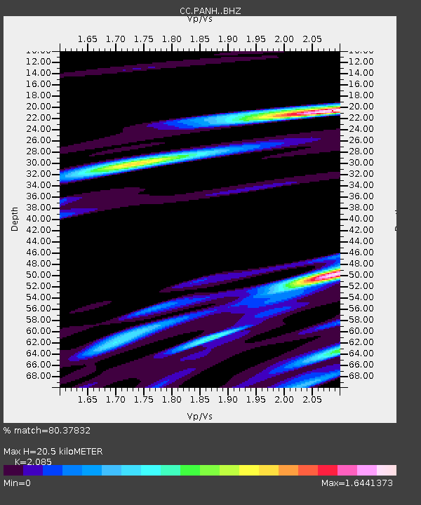
PANH Panhandle Gap - Earthquake Result Viewer
| Earthquake location: |
Near Coast Of Oaxaca, Mexico |
| Earthquake latitude/longitude: |
15.4/-97.1 |
| Earthquake time(UTC): |
2017/06/14 (165) 23:58:52 GMT |
| Earthquake Depth: |
6.9 km |
| Earthquake Magnitude: |
5.5 Mww |
| Earthquake Catalog/Contributor: |
NEIC PDE/us |
|
| Network: |
CC Cascade Chain Volcano Monitoring |
| Station: |
PANH Panhandle Gap |
| Lat/Lon: |
46.86 N/121.64 W |
| Elevation: |
2086 m |
|
| Distance: |
37.5 deg |
| Az: |
332.049 deg |
| Baz: |
138.781 deg |
| Ray Param: |
0.07612098 |
| Estimated Moho Depth: |
20.5 km |
| Estimated Crust Vp/Vs: |
2.09 |
| Assumed Crust Vp: |
6.597 km/s |
| Estimated Crust Vs: |
3.164 km/s |
| Estimated Crust Poisson's Ratio: |
0.35 |
|
| Radial Match: |
80.37832 % |
| Radial Bump: |
400 |
| Transverse Match: |
42.788994 % |
| Transverse Bump: |
400 |
| SOD ConfigId: |
13570011 |
| Insert Time: |
2019-04-28 05:14:34.522 +0000 |
| GWidth: |
2.5 |
| Max Bumps: |
400 |
| Tol: |
0.001 |
|

Signal To Noise
| Channel | StoN | STA | LTA |
| CC:PANH: :BHZ:20170615T00:05:34.399996Z | 1.3570939 | 1.4375115E-7 | 1.05925714E-7 |
| CC:PANH: :BHN:20170615T00:05:34.399996Z | 3.6506898 | 4.5775744E-7 | 1.2538929E-7 |
| CC:PANH: :BHE:20170615T00:05:34.399996Z | 0.89354837 | 2.0057597E-7 | 2.2447131E-7 |
| Arrivals |
| Ps | 3.6 SECOND |
| PpPs | 9.0 SECOND |
| PsPs/PpSs | 13 SECOND |


