You are here: Home > Network List > CN - Canadian National Seismograph Network Stations List
> Station FCC Fort Churchill, MB, CA > Earthquake Result Viewer
FCC Fort Churchill, MB, CA - Earthquake Result Viewer
| Earthquake location: |
Near Coast Of Oaxaca, Mexico |
| Earthquake latitude/longitude: |
15.4/-97.1 |
| Earthquake time(UTC): |
2017/06/14 (165) 23:58:52 GMT |
| Earthquake Depth: |
6.9 km |
| Earthquake Magnitude: |
5.5 Mww |
| Earthquake Catalog/Contributor: |
NEIC PDE/us |
|
| Network: |
CN Canadian National Seismograph Network |
| Station: |
FCC Fort Churchill, MB, CA |
| Lat/Lon: |
58.76 N/94.09 W |
| Elevation: |
39 m |
|
| Distance: |
43.4 deg |
| Az: |
2.275 deg |
| Baz: |
184.214 deg |
| Ray Param: |
0.07259083 |
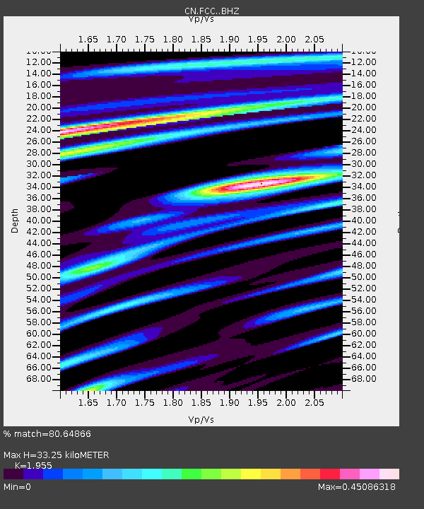
| Estimated Moho Depth: |
33.25 km |
| Estimated Crust Vp/Vs: |
1.96 |
| Assumed Crust Vp: |
6.455 km/s |
| Estimated Crust Vs: |
3.302 km/s |
| Estimated Crust Poisson's Ratio: |
0.32 |
|
| Radial Match: |
80.64866 % |
| Radial Bump: |
383 |
| Transverse Match: |
60.854183 % |
| Transverse Bump: |
400 |
| SOD ConfigId: |
13570011 |
| Insert Time: |
2019-04-28 05:14:52.017 +0000 |
| GWidth: |
2.5 |
| Max Bumps: |
400 |
| Tol: |
0.001 |
|

Signal To Noise
| Channel | StoN | STA | LTA |
| CN:FCC: :BHZ:20170615T00:06:23.500002Z | 4.447813 | 4.4023275E-7 | 9.897735E-8 |
| CN:FCC: :BHN:20170615T00:06:23.500002Z | 2.991364 | 2.7627294E-7 | 9.235685E-8 |
| CN:FCC: :BHE:20170615T00:06:23.500002Z | 0.9324842 | 6.909117E-8 | 7.409366E-8 |
| Arrivals |
| Ps | 5.2 SECOND |
| PpPs | 14 SECOND |
| PsPs/PpSs | 20 SECOND |


