You are here: Home > Network List > TA - USArray Transportable Network (new EarthScope stations) Stations List
> Station V30A Spur Ranch, Miami, TX, USA > Earthquake Result Viewer
V30A Spur Ranch, Miami, TX, USA - Earthquake Result Viewer

| Earthquake location: |
Tonga Islands |
| Earthquake latitude/longitude: |
-16.3/-173.5 |
| Earthquake time(UTC): |
2009/10/02 (275) 01:07:39 GMT |
| Earthquake Depth: |
8.0 km |
| Earthquake Magnitude: |
6.1 MB, 6.0 MS, 6.1 MW, 6.1 MW |
| Earthquake Catalog/Contributor: |
WHDF/NEIC |
|
| Network: |
TA USArray Transportable Network (new EarthScope stations) |
| Station: |
V30A Spur Ranch, Miami, TX, USA |
| Lat/Lon: |
35.76 N/100.69 W |
| Elevation: |
931 m |
|
| Distance: |
86.1 deg |
| Az: |
51.14 deg |
| Baz: |
246.82 deg |
| Ray Param: |
0.044315673 |
| Estimated Moho Depth: |
13.5 km |
| Estimated Crust Vp/Vs: |
2.10 |
| Assumed Crust Vp: |
6.426 km/s |
| Estimated Crust Vs: |
3.064 km/s |
| Estimated Crust Poisson's Ratio: |
0.35 |
|
| Radial Match: |
80.62871 % |
| Radial Bump: |
400 |
| Transverse Match: |
71.82946 % |
| Transverse Bump: |
400 |
| SOD ConfigId: |
2622 |
| Insert Time: |
2010-03-06 00:57:27.144 +0000 |
| GWidth: |
2.5 |
| Max Bumps: |
400 |
| Tol: |
0.001 |
|
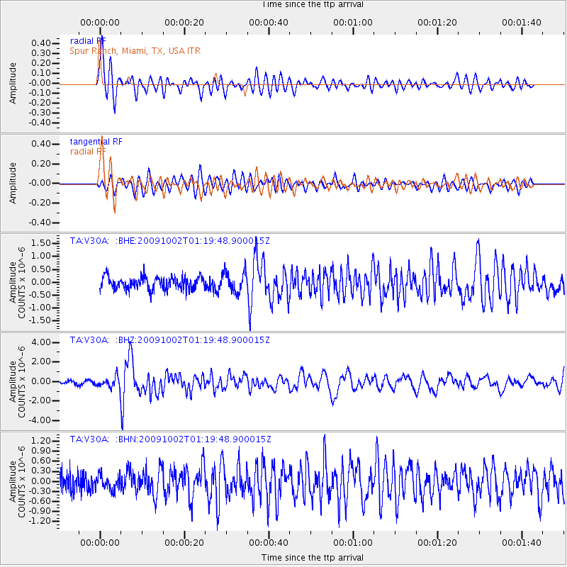
Signal To Noise
| Channel | StoN | STA | LTA |
| TA:V30A: :BHZ:20091002T01:19:48.900015Z | 3.320685 | 5.5364893E-7 | 1.6672733E-7 |
| TA:V30A: :BHN:20091002T01:19:48.900015Z | 0.80752987 | 2.1275547E-7 | 2.634645E-7 |
| TA:V30A: :BHE:20091002T01:19:48.900015Z | 1.5881256 | 3.8647983E-7 | 2.4335594E-7 |
| Arrivals |
| Ps | 2.4 SECOND |
| PpPs | 6.4 SECOND |
| PsPs/PpSs | 8.7 SECOND |


