You are here: Home > Network List > TA - USArray Transportable Network (new EarthScope stations) Stations List
> Station V31A Spring Creek Lake, Blk. Kettle Nat Grslnd, OK, USA > Earthquake Result Viewer
V31A Spring Creek Lake, Blk. Kettle Nat Grslnd, OK, USA - Earthquake Result Viewer
| Earthquake location: |
Norwegian Sea |
| Earthquake latitude/longitude: |
72.2/0.9 |
| Earthquake time(UTC): |
2009/08/20 (232) 06:35:04 GMT |
| Earthquake Depth: |
6.0 km |
| Earthquake Magnitude: |
5.9 MB, 5.7 MS, 6.0 MW, 6.0 MW |
| Earthquake Catalog/Contributor: |
WHDF/NEIC |
|
| Network: |
TA USArray Transportable Network (new EarthScope stations) |
| Station: |
V31A Spring Creek Lake, Blk. Kettle Nat Grslnd, OK, USA |
| Lat/Lon: |
35.77 N/99.84 W |
| Elevation: |
687 m |
|
| Distance: |
59.5 deg |
| Az: |
292.066 deg |
| Baz: |
20.519 deg |
| Ray Param: |
0.0621323 |
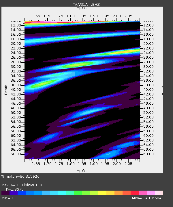
| Estimated Moho Depth: |
10.0 km |
| Estimated Crust Vp/Vs: |
1.81 |
| Assumed Crust Vp: |
6.315 km/s |
| Estimated Crust Vs: |
3.494 km/s |
| Estimated Crust Poisson's Ratio: |
0.28 |
|
| Radial Match: |
80.315926 % |
| Radial Bump: |
400 |
| Transverse Match: |
58.516296 % |
| Transverse Bump: |
400 |
| SOD ConfigId: |
2622 |
| Insert Time: |
2010-03-06 00:58:02.986 +0000 |
| GWidth: |
2.5 |
| Max Bumps: |
400 |
| Tol: |
0.001 |
|
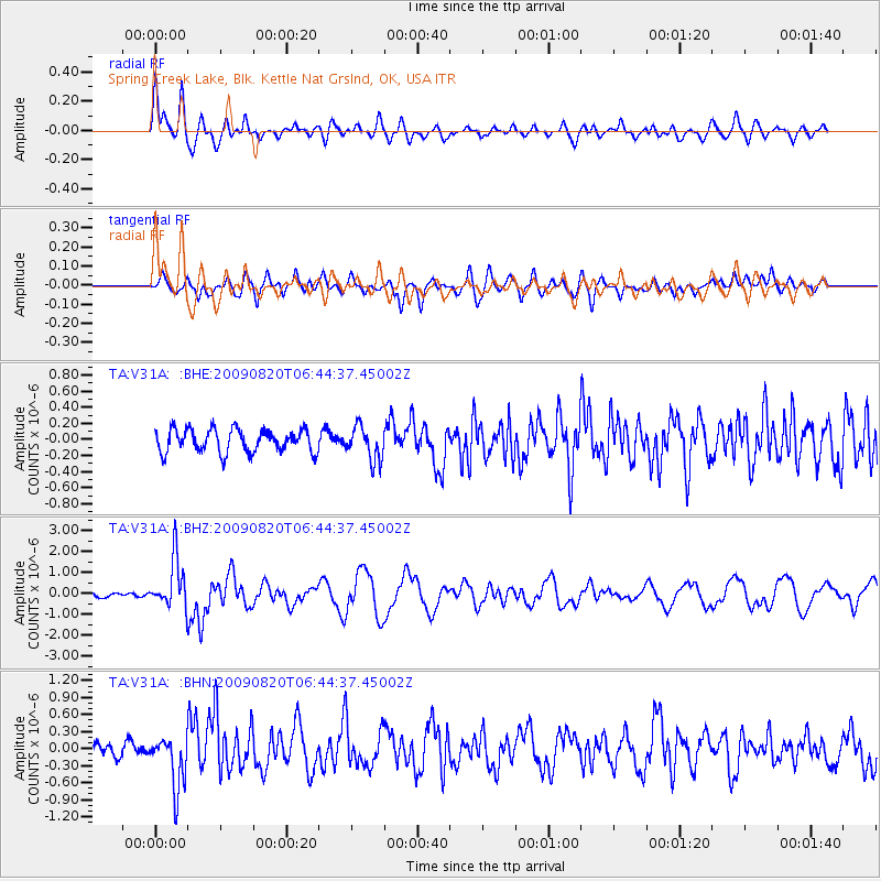
Signal To Noise
| Channel | StoN | STA | LTA |
| TA:V31A: :BHZ:20090820T06:44:37.45002Z | 12.662335 | 1.1725358E-6 | 9.2600274E-8 |
| TA:V31A: :BHN:20090820T06:44:37.45002Z | 4.7207823 | 4.5199823E-7 | 9.5746465E-8 |
| TA:V31A: :BHE:20090820T06:44:37.45002Z | 1.4424216 | 2.056811E-7 | 1.425943E-7 |
| Arrivals |
| Ps | 1.3 SECOND |
| PpPs | 4.3 SECOND |
| PsPs/PpSs | 5.6 SECOND |


