You are here: Home > Network List > TA - USArray Transportable Network (new EarthScope stations) Stations List
> Station V31A Spring Creek Lake, Blk. Kettle Nat Grslnd, OK, USA > Earthquake Result Viewer
V31A Spring Creek Lake, Blk. Kettle Nat Grslnd, OK, USA - Earthquake Result Viewer
| Earthquake location: |
Near Coast Of Venezuela |
| Earthquake latitude/longitude: |
10.7/-67.9 |
| Earthquake time(UTC): |
2009/09/12 (255) 20:06:24 GMT |
| Earthquake Depth: |
10 km |
| Earthquake Magnitude: |
6.3 MB, 6.4 MS, 6.3 MW, 6.3 MW |
| Earthquake Catalog/Contributor: |
WHDF/NEIC |
|
| Network: |
TA USArray Transportable Network (new EarthScope stations) |
| Station: |
V31A Spring Creek Lake, Blk. Kettle Nat Grslnd, OK, USA |
| Lat/Lon: |
35.77 N/99.84 W |
| Elevation: |
687 m |
|
| Distance: |
38.2 deg |
| Az: |
315.959 deg |
| Baz: |
122.839 deg |
| Ray Param: |
0.07569401 |
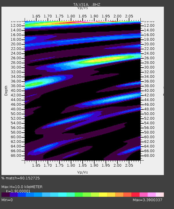
| Estimated Moho Depth: |
10.0 km |
| Estimated Crust Vp/Vs: |
1.91 |
| Assumed Crust Vp: |
6.315 km/s |
| Estimated Crust Vs: |
3.306 km/s |
| Estimated Crust Poisson's Ratio: |
0.31 |
|
| Radial Match: |
90.152725 % |
| Radial Bump: |
400 |
| Transverse Match: |
70.66703 % |
| Transverse Bump: |
400 |
| SOD ConfigId: |
2622 |
| Insert Time: |
2010-03-06 00:58:05.399 +0000 |
| GWidth: |
2.5 |
| Max Bumps: |
400 |
| Tol: |
0.001 |
|

Signal To Noise
| Channel | StoN | STA | LTA |
| TA:V31A: :BHZ:20090912T20:13:13.675005Z | 3.87709 | 1.0531826E-6 | 2.7164256E-7 |
| TA:V31A: :BHN:20090912T20:13:13.675005Z | 1.0388042 | 2.62588E-7 | 2.5277913E-7 |
| TA:V31A: :BHE:20090912T20:13:13.675005Z | 1.8679543 | 4.2660557E-7 | 2.2838117E-7 |
| Arrivals |
| Ps | 1.5 SECOND |
| PpPs | 4.3 SECOND |
| PsPs/PpSs | 5.9 SECOND |


