You are here: Home > Network List > UO - University of Oregon Regional Network Stations List
> Station WOOD Lake of the Woods, OR, USA > Earthquake Result Viewer
WOOD Lake of the Woods, OR, USA - Earthquake Result Viewer
| Earthquake location: |
Near Coast Of Oaxaca, Mexico |
| Earthquake latitude/longitude: |
15.4/-97.1 |
| Earthquake time(UTC): |
2017/06/14 (165) 23:58:52 GMT |
| Earthquake Depth: |
6.9 km |
| Earthquake Magnitude: |
5.5 Mww |
| Earthquake Catalog/Contributor: |
NEIC PDE/us |
|
| Network: |
UO University of Oregon Regional Network |
| Station: |
WOOD Lake of the Woods, OR, USA |
| Lat/Lon: |
42.22 N/122.30 W |
| Elevation: |
1437 m |
|
| Distance: |
34.5 deg |
| Az: |
325.988 deg |
| Baz: |
133.409 deg |
| Ray Param: |
0.07773742 |
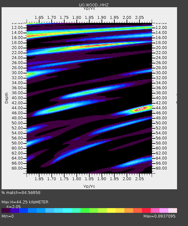
| Estimated Moho Depth: |
44.25 km |
| Estimated Crust Vp/Vs: |
2.05 |
| Assumed Crust Vp: |
6.522 km/s |
| Estimated Crust Vs: |
3.181 km/s |
| Estimated Crust Poisson's Ratio: |
0.34 |
|
| Radial Match: |
84.56958 % |
| Radial Bump: |
400 |
| Transverse Match: |
60.15222 % |
| Transverse Bump: |
400 |
| SOD ConfigId: |
13570011 |
| Insert Time: |
2019-04-28 05:19:36.443 +0000 |
| GWidth: |
2.5 |
| Max Bumps: |
400 |
| Tol: |
0.001 |
|

Signal To Noise
| Channel | StoN | STA | LTA |
| UO:WOOD: :HHZ:20170615T00:05:08.537997Z | 2.9994426 | 4.0340097E-7 | 1.3449197E-7 |
| UO:WOOD: :HHN:20170615T00:05:08.537997Z | 0.8602013 | 1.1180961E-7 | 1.2998076E-7 |
| UO:WOOD: :HHE:20170615T00:05:08.537997Z | 1.0384494 | 1.6194261E-7 | 1.5594655E-7 |
| Arrivals |
| Ps | 7.6 SECOND |
| PpPs | 19 SECOND |
| PsPs/PpSs | 27 SECOND |


