You are here: Home > Network List > US - United States National Seismic Network Stations List
> Station HAWA Hanford, Washington, USA > Earthquake Result Viewer
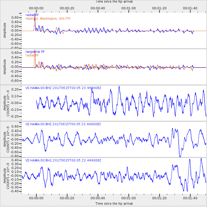
HAWA Hanford, Washington, USA - Earthquake Result Viewer
*The percent match for this event was below the threshold and hence no stack was calculated.
| Earthquake location: |
Near Coast Of Oaxaca, Mexico |
| Earthquake latitude/longitude: |
15.4/-97.1 |
| Earthquake time(UTC): |
2017/06/14 (165) 23:58:52 GMT |
| Earthquake Depth: |
6.9 km |
| Earthquake Magnitude: |
5.5 Mww |
| Earthquake Catalog/Contributor: |
NEIC PDE/us |
|
| Network: |
US United States National Seismic Network |
| Station: |
HAWA Hanford, Washington, USA |
| Lat/Lon: |
46.39 N/119.53 W |
| Elevation: |
364 m |
|
| Distance: |
36.2 deg |
| Az: |
333.41 deg |
| Baz: |
141.399 deg |
| Ray Param: |
$rayparam |
*The percent match for this event was below the threshold and hence was not used in the summary stack. |
|
| Radial Match: |
71.32689 % |
| Radial Bump: |
400 |
| Transverse Match: |
60.137573 % |
| Transverse Bump: |
400 |
| SOD ConfigId: |
13570011 |
| Insert Time: |
2019-04-28 05:19:38.039 +0000 |
| GWidth: |
2.5 |
| Max Bumps: |
400 |
| Tol: |
0.001 |
|
Signal To Noise
| Channel | StoN | STA | LTA |
| US:HAWA:00:BHZ:20170615T00:05:23.449008Z | 3.3155816 | 2.3599655E-7 | 7.117802E-8 |
| US:HAWA:00:BH1:20170615T00:05:23.449008Z | 2.6130667 | 1.1909582E-7 | 4.5577032E-8 |
| US:HAWA:00:BH2:20170615T00:05:23.449008Z | 1.6320955 | 8.621511E-8 | 5.28248E-8 |
| Arrivals |
| Ps | |
| PpPs | |
| PsPs/PpSs | |


