You are here: Home > Network List > UW - Pacific Northwest Regional Seismic Network Stations List
> Station KENT Carlson Farm, Grass Valley, OR, USA > Earthquake Result Viewer
KENT Carlson Farm, Grass Valley, OR, USA - Earthquake Result Viewer
| Earthquake location: |
Near Coast Of Oaxaca, Mexico |
| Earthquake latitude/longitude: |
15.4/-97.1 |
| Earthquake time(UTC): |
2017/06/14 (165) 23:58:52 GMT |
| Earthquake Depth: |
6.9 km |
| Earthquake Magnitude: |
5.5 Mww |
| Earthquake Catalog/Contributor: |
NEIC PDE/us |
|
| Network: |
UW Pacific Northwest Regional Seismic Network |
| Station: |
KENT Carlson Farm, Grass Valley, OR, USA |
| Lat/Lon: |
45.24 N/120.64 W |
| Elevation: |
780 m |
|
| Distance: |
35.8 deg |
| Az: |
331.141 deg |
| Baz: |
138.775 deg |
| Ray Param: |
0.07703829 |
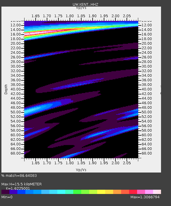
| Estimated Moho Depth: |
15.5 km |
| Estimated Crust Vp/Vs: |
1.62 |
| Assumed Crust Vp: |
6.597 km/s |
| Estimated Crust Vs: |
4.066 km/s |
| Estimated Crust Poisson's Ratio: |
0.19 |
|
| Radial Match: |
86.64083 % |
| Radial Bump: |
340 |
| Transverse Match: |
46.861732 % |
| Transverse Bump: |
400 |
| SOD ConfigId: |
13570011 |
| Insert Time: |
2019-04-28 05:19:43.981 +0000 |
| GWidth: |
2.5 |
| Max Bumps: |
400 |
| Tol: |
0.001 |
|
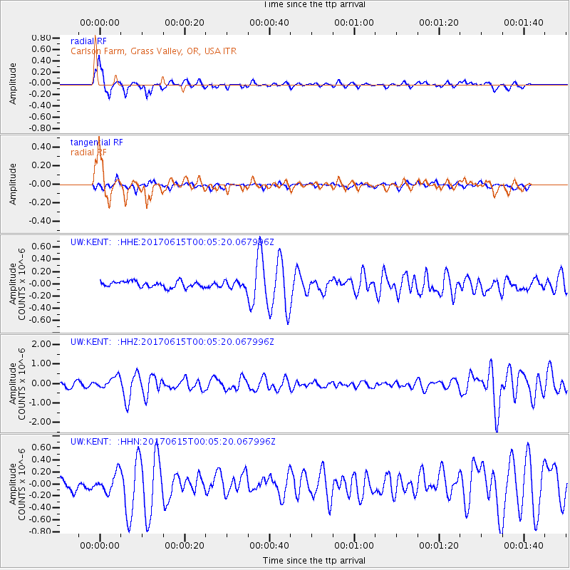
Signal To Noise
| Channel | StoN | STA | LTA |
| UW:KENT: :HHZ:20170615T00:05:20.067996Z | 3.0617857 | 3.0032055E-7 | 9.808672E-8 |
| UW:KENT: :HHN:20170615T00:05:20.067996Z | 1.6943296 | 1.6574779E-7 | 9.7824994E-8 |
| UW:KENT: :HHE:20170615T00:05:20.067996Z | 3.2983947 | 1.624087E-7 | 4.923871E-8 |
| Arrivals |
| Ps | 1.6 SECOND |
| PpPs | 5.6 SECOND |
| PsPs/PpSs | 7.2 SECOND |


