You are here: Home > Network List > TA - USArray Transportable Network (new EarthScope stations) Stations List
> Station T29A Hugoton, KS, USA > Earthquake Result Viewer
T29A Hugoton, KS, USA - Earthquake Result Viewer
| Earthquake location: |
Hokkaido, Japan Region |
| Earthquake latitude/longitude: |
41.8/143.4 |
| Earthquake time(UTC): |
2009/06/05 (156) 03:30:33 GMT |
| Earthquake Depth: |
29 km |
| Earthquake Magnitude: |
6.0 MB, 6.3 MS, 6.4 MW, 6.4 MW |
| Earthquake Catalog/Contributor: |
WHDF/NEIC |
|
| Network: |
TA USArray Transportable Network (new EarthScope stations) |
| Station: |
T29A Hugoton, KS, USA |
| Lat/Lon: |
37.16 N/101.29 W |
| Elevation: |
936 m |
|
| Distance: |
81.7 deg |
| Az: |
46.905 deg |
| Baz: |
316.911 deg |
| Ray Param: |
0.04738106 |
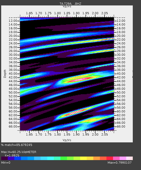
| Estimated Moho Depth: |
60.25 km |
| Estimated Crust Vp/Vs: |
1.89 |
| Assumed Crust Vp: |
6.483 km/s |
| Estimated Crust Vs: |
3.425 km/s |
| Estimated Crust Poisson's Ratio: |
0.31 |
|
| Radial Match: |
85.679245 % |
| Radial Bump: |
400 |
| Transverse Match: |
72.36917 % |
| Transverse Bump: |
400 |
| SOD ConfigId: |
2648 |
| Insert Time: |
2010-03-06 00:59:14.740 +0000 |
| GWidth: |
2.5 |
| Max Bumps: |
400 |
| Tol: |
0.001 |
|

Signal To Noise
| Channel | StoN | STA | LTA |
| TA:T29A: :BHZ:20090605T03:42:17.349001Z | 4.889497 | 5.9240926E-7 | 1.2115956E-7 |
| TA:T29A: :BHN:20090605T03:42:17.349001Z | 2.1345153 | 2.5703528E-7 | 1.2041858E-7 |
| TA:T29A: :BHE:20090605T03:42:17.349001Z | 1.4668995 | 1.4852624E-7 | 1.01251814E-7 |
| Arrivals |
| Ps | 8.5 SECOND |
| PpPs | 26 SECOND |
| PsPs/PpSs | 35 SECOND |


