You are here: Home > Network List > TA - USArray Transportable Network (new EarthScope stations) Stations List
> Station P17K Kvichak River, AK, USA > Earthquake Result Viewer
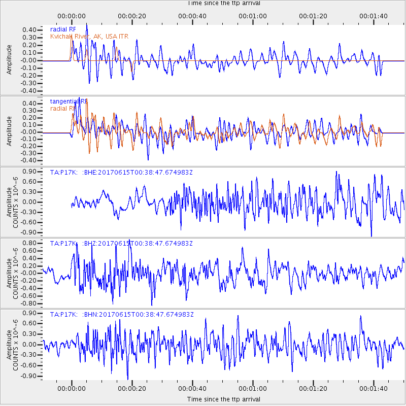
P17K Kvichak River, AK, USA - Earthquake Result Viewer
*The percent match for this event was below the threshold and hence no stack was calculated.
| Earthquake location: |
Kermadec Islands, New Zealand |
| Earthquake latitude/longitude: |
-30.6/-178.0 |
| Earthquake time(UTC): |
2017/06/15 (166) 00:26:16 GMT |
| Earthquake Depth: |
24 km |
| Earthquake Magnitude: |
5.9 Mww |
| Earthquake Catalog/Contributor: |
NEIC PDE/us |
|
| Network: |
TA USArray Transportable Network (new EarthScope stations) |
| Station: |
P17K Kvichak River, AK, USA |
| Lat/Lon: |
59.20 N/156.44 W |
| Elevation: |
91 m |
|
| Distance: |
91.2 deg |
| Az: |
10.903 deg |
| Baz: |
198.482 deg |
| Ray Param: |
$rayparam |
*The percent match for this event was below the threshold and hence was not used in the summary stack. |
|
| Radial Match: |
67.88602 % |
| Radial Bump: |
400 |
| Transverse Match: |
66.607 % |
| Transverse Bump: |
400 |
| SOD ConfigId: |
13570011 |
| Insert Time: |
2019-04-28 05:25:07.604 +0000 |
| GWidth: |
2.5 |
| Max Bumps: |
400 |
| Tol: |
0.001 |
|
Signal To Noise
| Channel | StoN | STA | LTA |
| TA:P17K: :BHZ:20170615T00:38:47.674983Z | 2.2906172 | 3.7251104E-7 | 1.6262473E-7 |
| TA:P17K: :BHN:20170615T00:38:47.674983Z | 1.5340028 | 1.9619179E-7 | 1.2789533E-7 |
| TA:P17K: :BHE:20170615T00:38:47.674983Z | 0.95290244 | 1.8778177E-7 | 1.9706295E-7 |
| Arrivals |
| Ps | |
| PpPs | |
| PsPs/PpSs | |


