You are here: Home > Network List > TA - USArray Transportable Network (new EarthScope stations) Stations List
> Station U27A Thompson Grove, Rita Blanca Nat Grassland, TX, USA > Earthquake Result Viewer
U27A Thompson Grove, Rita Blanca Nat Grassland, TX, USA - Earthquake Result Viewer
| Earthquake location: |
Off Coast Of Ecuador |
| Earthquake latitude/longitude: |
1.4/-85.2 |
| Earthquake time(UTC): |
2009/05/10 (130) 01:16:06 GMT |
| Earthquake Depth: |
6.0 km |
| Earthquake Magnitude: |
5.5 MB, 5.7 MS, 6.1 MW, 6.1 MW |
| Earthquake Catalog/Contributor: |
WHDF/NEIC |
|
| Network: |
TA USArray Transportable Network (new EarthScope stations) |
| Station: |
U27A Thompson Grove, Rita Blanca Nat Grassland, TX, USA |
| Lat/Lon: |
36.42 N/102.82 W |
| Elevation: |
1342 m |
|
| Distance: |
38.5 deg |
| Az: |
336.86 deg |
| Baz: |
150.851 deg |
| Ray Param: |
0.0755374 |
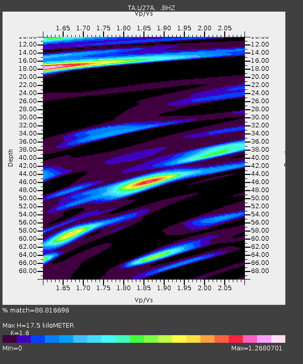
| Estimated Moho Depth: |
17.5 km |
| Estimated Crust Vp/Vs: |
1.60 |
| Assumed Crust Vp: |
6.306 km/s |
| Estimated Crust Vs: |
3.941 km/s |
| Estimated Crust Poisson's Ratio: |
0.18 |
|
| Radial Match: |
88.816696 % |
| Radial Bump: |
400 |
| Transverse Match: |
74.45798 % |
| Transverse Bump: |
400 |
| SOD ConfigId: |
2760 |
| Insert Time: |
2010-03-06 01:00:07.011 +0000 |
| GWidth: |
2.5 |
| Max Bumps: |
400 |
| Tol: |
0.001 |
|

Signal To Noise
| Channel | StoN | STA | LTA |
| TA:U27A: :BHZ:20090510T01:22:59.025002Z | 6.591407 | 7.3855045E-7 | 1.12047466E-7 |
| TA:U27A: :BHN:20090510T01:22:59.025002Z | 2.6870456 | 2.9761955E-7 | 1.10760894E-7 |
| TA:U27A: :BHE:20090510T01:22:59.025002Z | 2.091908 | 2.4427044E-7 | 1.1676921E-7 |
| Arrivals |
| Ps | 1.8 SECOND |
| PpPs | 6.7 SECOND |
| PsPs/PpSs | 8.5 SECOND |


