You are here: Home > Network List > TA - USArray Transportable Network (new EarthScope stations) Stations List
> Station U27A Thompson Grove, Rita Blanca Nat Grassland, TX, USA > Earthquake Result Viewer
U27A Thompson Grove, Rita Blanca Nat Grassland, TX, USA - Earthquake Result Viewer
| Earthquake location: |
Norwegian Sea |
| Earthquake latitude/longitude: |
72.2/0.9 |
| Earthquake time(UTC): |
2009/08/20 (232) 06:35:04 GMT |
| Earthquake Depth: |
6.0 km |
| Earthquake Magnitude: |
5.9 MB, 5.7 MS, 6.0 MW, 6.0 MW |
| Earthquake Catalog/Contributor: |
WHDF/NEIC |
|
| Network: |
TA USArray Transportable Network (new EarthScope stations) |
| Station: |
U27A Thompson Grove, Rita Blanca Nat Grassland, TX, USA |
| Lat/Lon: |
36.42 N/102.82 W |
| Elevation: |
1342 m |
|
| Distance: |
59.8 deg |
| Az: |
294.95 deg |
| Baz: |
20.227 deg |
| Ray Param: |
0.06197791 |
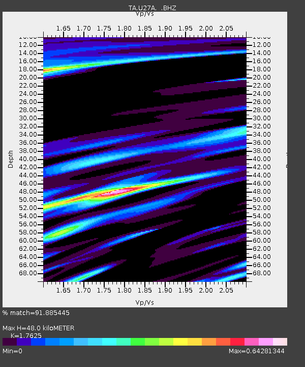
| Estimated Moho Depth: |
48.0 km |
| Estimated Crust Vp/Vs: |
1.76 |
| Assumed Crust Vp: |
6.306 km/s |
| Estimated Crust Vs: |
3.578 km/s |
| Estimated Crust Poisson's Ratio: |
0.26 |
|
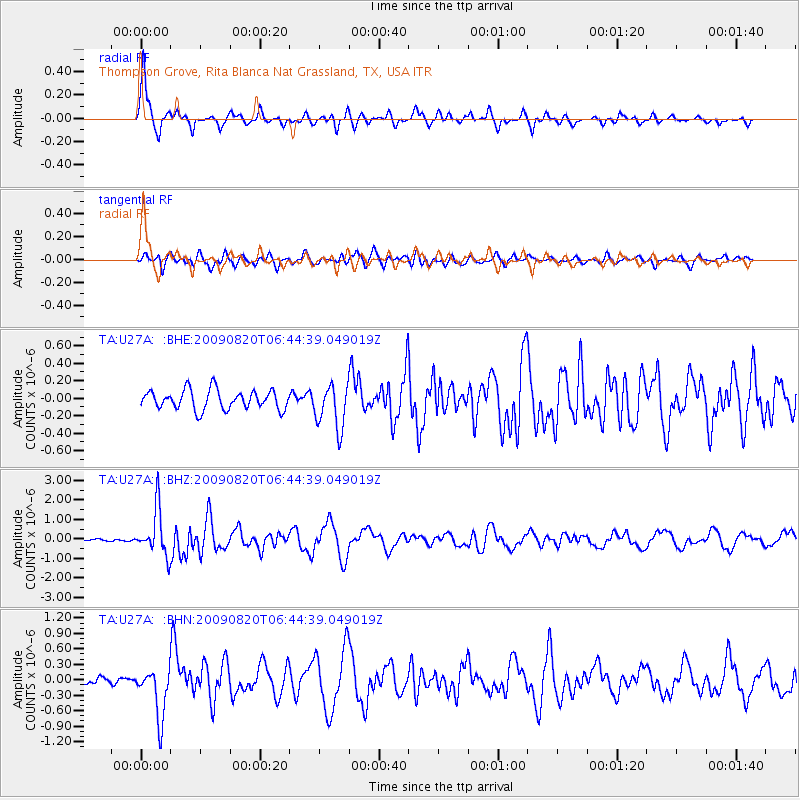
| Radial Match: |
91.885445 % |
| Radial Bump: |
370 |
| Transverse Match: |
75.64707 % |
| Transverse Bump: |
400 |
| SOD ConfigId: |
2622 |
| Insert Time: |
2010-03-06 01:00:14.122 +0000 |
| GWidth: |
2.5 |
| Max Bumps: |
400 |
| Tol: |
0.001 |
|
Signal To Noise
| Channel | StoN | STA | LTA |
| TA:U27A: :BHZ:20090820T06:44:39.049019Z | 24.791271 | 1.1773833E-6 | 4.749185E-8 |
| TA:U27A: :BHN:20090820T06:44:39.049019Z | 5.8262634 | 4.860515E-7 | 8.342422E-8 |
| TA:U27A: :BHE:20090820T06:44:39.049019Z | 2.2941375 | 2.5378412E-7 | 1.1062289E-7 |
| Arrivals |
| Ps | 6.1 SECOND |
| PpPs | 20 SECOND |
| PsPs/PpSs | 26 SECOND |


