You are here: Home > Network List > TA - USArray Transportable Network (new EarthScope stations) Stations List
> Station U27A Thompson Grove, Rita Blanca Nat Grassland, TX, USA > Earthquake Result Viewer
U27A Thompson Grove, Rita Blanca Nat Grassland, TX, USA - Earthquake Result Viewer
| Earthquake location: |
Baffin Bay |
| Earthquake latitude/longitude: |
75.4/-72.5 |
| Earthquake time(UTC): |
2009/07/07 (188) 19:11:46 GMT |
| Earthquake Depth: |
19 km |
| Earthquake Magnitude: |
5.9 MB, 5.7 MS, 6.1 MW, 6.0 MW |
| Earthquake Catalog/Contributor: |
WHDF/NEIC |
|
| Network: |
TA USArray Transportable Network (new EarthScope stations) |
| Station: |
U27A Thompson Grove, Rita Blanca Nat Grassland, TX, USA |
| Lat/Lon: |
36.42 N/102.82 W |
| Elevation: |
1342 m |
|
| Distance: |
41.5 deg |
| Az: |
217.97 deg |
| Baz: |
11.194 deg |
| Ray Param: |
0.07371862 |
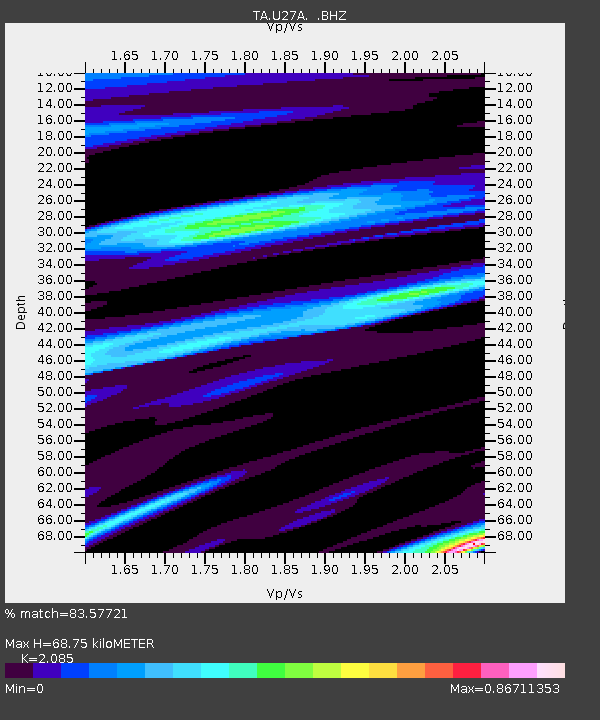
| Estimated Moho Depth: |
68.75 km |
| Estimated Crust Vp/Vs: |
2.09 |
| Assumed Crust Vp: |
6.306 km/s |
| Estimated Crust Vs: |
3.024 km/s |
| Estimated Crust Poisson's Ratio: |
0.35 |
|
| Radial Match: |
83.57721 % |
| Radial Bump: |
365 |
| Transverse Match: |
74.26837 % |
| Transverse Bump: |
400 |
| SOD ConfigId: |
2648 |
| Insert Time: |
2010-03-06 01:00:31.396 +0000 |
| GWidth: |
2.5 |
| Max Bumps: |
400 |
| Tol: |
0.001 |
|

Signal To Noise
| Channel | StoN | STA | LTA |
| TA:U27A: :BHZ:20090707T19:19:01.875009Z | 8.512811 | 1.2076013E-6 | 1.4185694E-7 |
| TA:U27A: :BHN:20090707T19:19:01.875009Z | 6.3762403 | 7.802144E-7 | 1.2236276E-7 |
| TA:U27A: :BHE:20090707T19:19:01.875009Z | 2.6225464 | 2.6885093E-7 | 1.0251522E-7 |
| Arrivals |
| Ps | 13 SECOND |
| PpPs | 32 SECOND |
| PsPs/PpSs | 44 SECOND |


