You are here: Home > Network List > TA - USArray Transportable Network (new EarthScope stations) Stations List
> Station U31A Nine Bar Ranch, Gage, OK, USA > Earthquake Result Viewer
U31A Nine Bar Ranch, Gage, OK, USA - Earthquake Result Viewer
| Earthquake location: |
Norwegian Sea |
| Earthquake latitude/longitude: |
72.2/0.9 |
| Earthquake time(UTC): |
2009/08/20 (232) 06:35:04 GMT |
| Earthquake Depth: |
6.0 km |
| Earthquake Magnitude: |
5.9 MB, 5.7 MS, 6.0 MW, 6.0 MW |
| Earthquake Catalog/Contributor: |
WHDF/NEIC |
|
| Network: |
TA USArray Transportable Network (new EarthScope stations) |
| Station: |
U31A Nine Bar Ranch, Gage, OK, USA |
| Lat/Lon: |
36.37 N/99.85 W |
| Elevation: |
725 m |
|
| Distance: |
59.0 deg |
| Az: |
292.316 deg |
| Baz: |
20.642 deg |
| Ray Param: |
0.062498506 |
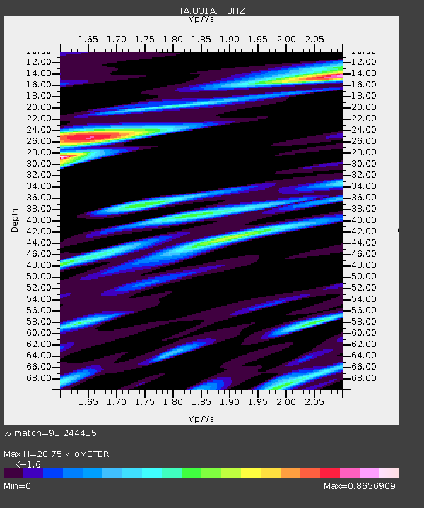
| Estimated Moho Depth: |
28.75 km |
| Estimated Crust Vp/Vs: |
1.60 |
| Assumed Crust Vp: |
6.426 km/s |
| Estimated Crust Vs: |
4.016 km/s |
| Estimated Crust Poisson's Ratio: |
0.18 |
|
| Radial Match: |
91.244415 % |
| Radial Bump: |
400 |
| Transverse Match: |
71.05865 % |
| Transverse Bump: |
400 |
| SOD ConfigId: |
2622 |
| Insert Time: |
2010-03-06 01:01:44.788 +0000 |
| GWidth: |
2.5 |
| Max Bumps: |
400 |
| Tol: |
0.001 |
|
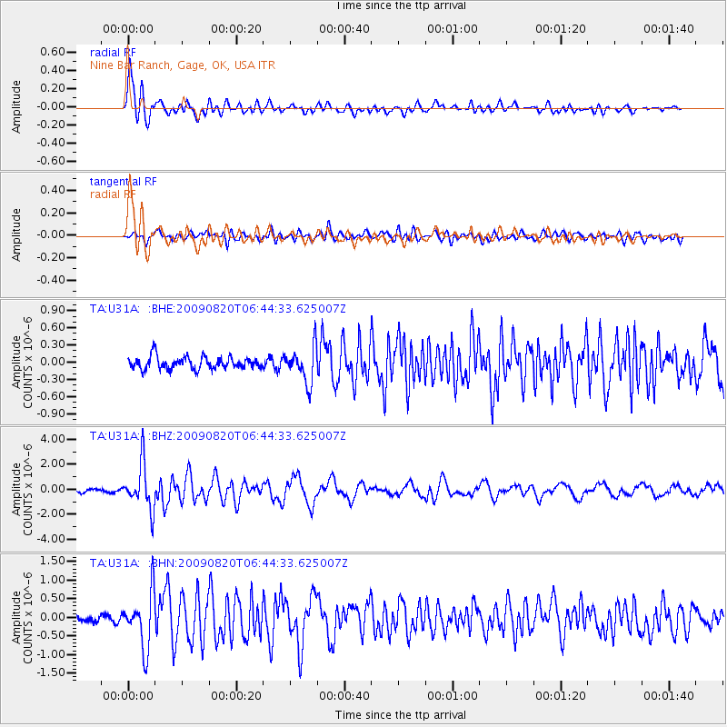
Signal To Noise
| Channel | StoN | STA | LTA |
| TA:U31A: :BHZ:20090820T06:44:33.625007Z | 17.459469 | 1.8285758E-6 | 1.04732614E-7 |
| TA:U31A: :BHN:20090820T06:44:33.625007Z | 6.2523685 | 7.4908274E-7 | 1.1980784E-7 |
| TA:U31A: :BHE:20090820T06:44:33.625007Z | 2.9729502 | 3.1553265E-7 | 1.0613452E-7 |
| Arrivals |
| Ps | 2.8 SECOND |
| PpPs | 11 SECOND |
| PsPs/PpSs | 14 SECOND |


