You are here: Home > Network List > TA - USArray Transportable Network (new EarthScope stations) Stations List
> Station F26K Sheenjek River, AK, USA > Earthquake Result Viewer
F26K Sheenjek River, AK, USA - Earthquake Result Viewer
*The percent match for this event was below the threshold and hence no stack was calculated.
| Earthquake location: |
Near Coast Of Nicaragua |
| Earthquake latitude/longitude: |
11.3/-86.7 |
| Earthquake time(UTC): |
2017/06/17 (168) 13:47:38 GMT |
| Earthquake Depth: |
28 km |
| Earthquake Magnitude: |
5.4 Mww |
| Earthquake Catalog/Contributor: |
NEIC PDE/us |
|
| Network: |
TA USArray Transportable Network (new EarthScope stations) |
| Station: |
F26K Sheenjek River, AK, USA |
| Lat/Lon: |
67.69 N/144.15 W |
| Elevation: |
683 m |
|
| Distance: |
67.6 deg |
| Az: |
339.634 deg |
| Baz: |
116.581 deg |
| Ray Param: |
$rayparam |
*The percent match for this event was below the threshold and hence was not used in the summary stack. |
|
| Radial Match: |
63.162464 % |
| Radial Bump: |
400 |
| Transverse Match: |
52.010242 % |
| Transverse Bump: |
400 |
| SOD ConfigId: |
13570011 |
| Insert Time: |
2019-04-28 05:39:25.800 +0000 |
| GWidth: |
2.5 |
| Max Bumps: |
400 |
| Tol: |
0.001 |
|
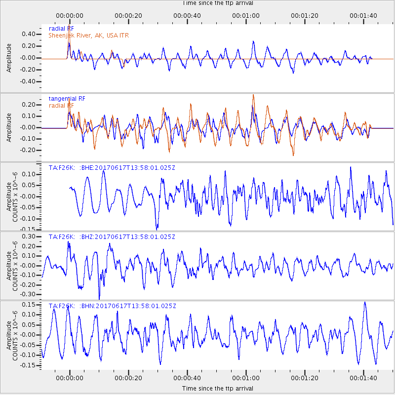
Signal To Noise
| Channel | StoN | STA | LTA |
| TA:F26K: :BHZ:20170617T13:58:01.025Z | 3.284341 | 1.6442473E-7 | 5.0063232E-8 |
| TA:F26K: :BHN:20170617T13:58:01.025Z | 1.3975495 | 7.398495E-8 | 5.2939054E-8 |
| TA:F26K: :BHE:20170617T13:58:01.025Z | 1.3141799 | 6.7329864E-8 | 5.123337E-8 |
| Arrivals |
| Ps | |
| PpPs | |
| PsPs/PpSs | |


